
Congrier
| Congrier | ||
|---|---|---|

|
|
|
| region | Pays de la Loire | |
| Department | Mayenne | |
| Arrondissement | Château-Gontier | |
| Canton | Cossé-le-Vivien | |
| Community association | Pays de Craon | |
| Coordinates | 47 ° 49 ′ N , 1 ° 7 ′ W | |
| height | 56-106 m | |
| surface | 24.28 km 2 | |
| Residents | 896 (January 1, 2017) | |
| Population density | 37 inhabitants / km 2 | |
| Post Code | 53800 | |
| INSEE code | 53073 | |
| Website | www.congrier.fr | |
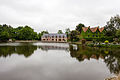
 City Hall (Mairie) of Congrier |
||

Congrier is a commune with 896 inhabitants (as of January 1 2017) in Mayenne in the region Pays de la Loire . The municipality belongs to the canton of Cossé-le-Vivien (until 2015: canton of Saint-Aignan-sur-Roë ) in the arrondissement of Château-Gontier . Residents of the municipality arecalled congriéens .
geography
Congrier is about 42 kilometers southwest of Laval . In the south, the Usure limits the community. Congrier is surrounded by the neighboring communities of Saint-Aignan-sur-Roë in the north, Saint-Saturnin-du-Limet in the north and northeast, Renazé in the east, Ombrée d'Anjou in the south, Saint-Erblon in the southwest, Senonnes in the west and La Rouaudière in the northwest.
Population development
| year | 1962 | 1968 | 1975 | 1982 | 1990 | 1999 | 2006 | 2013 | ||||
|---|---|---|---|---|---|---|---|---|---|---|---|---|
| Residents | 1.103 | 1,046 | 910 | 975 | 1,035 | 1,036 | 955 | 921 | ||||
| Source: Cassini and INSEE | ||||||||||||
Attractions
- Saint-Pierre-aux-Liens church from the 19th century
- La Chevronnaie Castle
- Bailiwick

Saint-Pierre-aux-Liens church
Bailiwick


literature
- Le Patrimoine des Communes de la Mayenne. Flohic Editions, Volume 2, Paris 2002, ISBN 2-84234-135-X , pp. 831-834.
Web links
Commons : Congrier - collection of images, videos and audio files