
Bazougers
| Bazougers | ||
|---|---|---|
|
||
| region | Pays de la Loire | |
| Department | Mayenne | |
| Arrondissement | Château-Gontier | |
| Canton | Meslay-du-Maine | |
| Community association | Pays de Meslay-Grez | |
| Coordinates | 48 ° 2 ′ N , 0 ° 29 ′ W | |
| height | 52-108 m | |
| surface | 31.72 km 2 | |
| Residents | 1,106 (January 1, 2017) | |
| Population density | 35 inhabitants / km 2 | |
| Post Code | 53170 | |
| INSEE code | 53025 | |
| Website | http://www.bazougers.mairie53.fr/ | |
 Town Hall (Mairie) of Bazougers |
||

Bazougers is a French commune with 1,106 inhabitants (as of January 1 2017) in Mayenne in the region Pays de la Loire in France . Residents of the municipality are called Bazougerois . The municipality belongs to the arrondissement of Château-Gontier and the canton of Meslay-du-Maine .
geography
Bazougers is about 16 kilometers east-southeast of Laval . Bazougers is surrounded by the neighboring communities Louvigné in the north and northwest, Soulgé-sur-Ouette in the north, Saint-Georges-le-Fléchard in the northeast, La Bazouge-de-Chemeré in the east, Arquenay in the south and Parné-sur-Roc in the west and southwest.
Population development
| year | 1962 | 1968 | 1975 | 1982 | 1990 | 1999 | 2006 | 2013 |
| Residents | 840 | 781 | 743 | 864 | 869 | 933 | 976 | 1,136 |
| Source: Cassini and INSEE | ||||||||
Attractions
- Menhir de la Hune
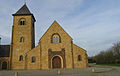
- Saint-Victeur church
- Sainte-Marie-Madeleine Chapel from 1090
- Cotellerie Priory
- Saint-Victeur Priory, built between 1480 and 1520

Menhir de la Hune

Saint-Victor church
Cotellerie Priory

_%C3%89glise_01.JPG)

Personalities
- Francis Delaisi (1873–1947), trade unionist, journalist and writer
literature
- Le Patrimoine des Communes de la Mayenne. Flohic Editions, Volume 2, Paris 2002, ISBN 2-84234-135-X , pp. 750-752.
Web links
Commons : Bazougers - collection of images, videos and audio files