
Soulgé-sur-Ouette
| Soulgé-sur-Ouette | ||
|---|---|---|
|
||
| region | Pays de la Loire | |
| Department | Mayenne | |
| Arrondissement | Laval | |
| Canton | L'Huisserie | |
| Community association | Laval | |
| Coordinates | 48 ° 4 ′ N , 0 ° 34 ′ W | |
| height | 74-124 m | |
| surface | 22.94 km 2 | |
| Residents | 1,084 (January 1, 2017) | |
| Population density | 47 inhabitants / km 2 | |
| Post Code | 53210 | |
| INSEE code | 53262 | |
| Website | http://www.soulgesurouette.fr/ | |

Soulgé-sur-Ouette is a commune with 1,084 inhabitants (as of January 1 2017) in Mayenne in the region Pays de la Loire . It belongs to the Arrondissement Laval and the Canton of L'Huisserie (until 2015: Canton of Montsûrs ). The inhabitants are called Soulgéens .
geography
Soulgé-sur-Ouette is about ten kilometers east of Laval . Soulgé-sur-Ouette is surrounded by the neighboring communities Argentré in the north and north-west, La Chapelle-Rainsouin in the north and north-east, Vaiges in the east and south-east, Saint-Georges-le-Fléchard in the south and south-east, Bazougers in the south and south-west and Louvigné in the West.
history
In 1978 the previously independent communes of Soulgé-le-Bruant and Nuillé-sur-Ouette were merged.
Population development
| year | 1962 | 1968 | 1975 | 1982 | 1990 | 1999 | 2006 | 2013 |
|---|---|---|---|---|---|---|---|---|
| Residents | 539 | 527 | 748 | 817 | 889 | 971 | 1,073 | 1.104 |
| Source: Cassini and INSEE | ||||||||
Attractions
- Saint-Médard church
- Saint-Martin church in Nuillé from the 11th century, historic monument since 1997
- Les Arcis Castle

Saint-Médard church
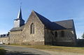
Saint Martin Church


Personalities
- Raymond Delatouche (1906–2002), historian and agronomist
literature
- Le Patrimoine des Communes de la Mayenne. Flohic Editions, Volume 2, Paris 2002, ISBN 2-84234-135-X , pp. 805-808.