
Ahuillé
| Ahuillé | ||
|---|---|---|
|
||
| region | Pays de la Loire | |
| Department | Mayenne | |
| Arrondissement | Laval | |
| Canton | L'Huisserie | |
| Community association | Laval | |
| Coordinates | 48 ° 1 ′ N , 0 ° 52 ′ W | |
| height | 63-130 m | |
| surface | 28.97 km 2 | |
| Residents | 1,806 (January 1, 2017) | |
| Population density | 62 inhabitants / km 2 | |
| Post Code | 53940 | |
| INSEE code | 53001 | |
| Website | http://www.ahuille.mairie53.fr/ | |

Ahuillé is a French commune with 1,806 inhabitants (as of January 1 2017) in Mayenne in the region Pays de la Loire ; it belongs to the Arrondissement Laval and the canton L'Huisserie (until 2015: canton Saint-Berthevin ). The inhabitants are called Ahuilléens .
history
Ahuillé is first mentioned in 616 as "Hiliacus" in the will of St. Bertrand († 623), Bishop of Le Mans .
geography
Ahuillé is about eight kilometers southeast of Laval . Ahuillé is surrounded by the neighboring communities of Loiron-Ruillé in the north and northwest, Saint-Berthevin in the north and northeast, Montigné-le-Brillant in the east, Astillé and Courbeveille in the south and Montjean in the west and southwest.
Population development
| year | 1962 | 1968 | 1975 | 1982 | 1990 | 1999 | 2006 | 2013 |
| Residents | 902 | 841 | 885 | 1,454 | 1,399 | 1,379 | 1,174 | 1,292 |
| Source: Cassini and INSEE | ||||||||
Attractions
- Menhir La Pierre-du-Fau
- Notre-Dame-de-l'Assomption church
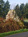
Menhir La Pierre-du-Fau

Notre-Dame-de-l'Assomption church


Community partnerships
A partnership has existed with the German community of Gundremmingen in Swabia (Bavaria) since 1983.
Personalities
- Édouard Sorin (1814-1893), priest
literature
- Le Patrimoine des Communes de la Mayenne. Flohic Editions, Volume 2, Paris 2002, ISBN 2-84234-135-X , pp. 859-861.