Canton of Saint-Berthevin
| Canton of Saint-Berthevin | |
|---|---|
| region | Pays de la Loire |
| Department | Mayenne |
| Arrondissement | Laval |
| main place | Saint-Berthevin |
| Residents | 16,183 (Jan. 1, 2017) |
| Population density | 162 inhabitants / km² |
| surface | 100.08 km² |
| Communities | 4th |
| INSEE code | 5316 |
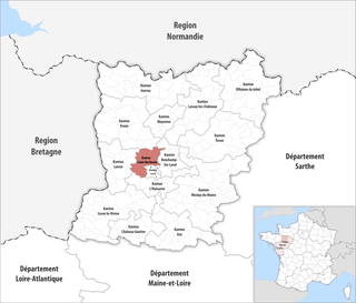
 Location of the canton of Saint-Berthevin in the Mayenne department |
|
The District of Saint-Berthevin is a French canton in the Arrondissement Laval , in Mayenne and the region Pays de la Loire ; its main town is Saint-Berthevin . Yannick Borde has been a representative in the General Council of the Département since 2011 (first DVD , then UDI ).
Communities
The canton consists of four municipalities with a total of 16,183 inhabitants (as of 2017) on a total area of 100.08 km 2 :
| local community | Residents January 1, 2017 |
Area km² |
Density of population / km² |
Code INSEE |
Post Code |
|---|---|---|---|---|---|
| Changé | 6,020 | 34.68 | 174 | 53054 | 53810 |
| Saint-Berthevin | 7,344 | 32.11 | 229 | 53201 | 53940 |
| Saint-Germain-le-Fouilloux | 1.166 | 15.48 | 75 | 53224 | 53240 |
| Saint-Jean-sur-Mayenne | 1,653 | 17.81 | 93 | 53229 | 53240 |
| Canton of Saint-Berthevin | 16,183 | 100.08 | 162 | 5316 | - |
Until the nationwide reorganization of the cantons in March 2015, the canton of Saint-Berthevin consisted of the seven municipalities of Ahuillé , Astillé , Courbeveille , L'Huisserie , Montigné-le-Brillant , Nuillé-sur-Vicoin and Saint-Berthevin (main town). Its layout corresponded to an area of 157.09 km 2 . Before 2015 it had a different INSEE code than it does today, namely 5332.
Population development
| 1962 | 1968 | 1975 | 1982 | 1990 | 1999 | 2006 | 2011 |
|---|---|---|---|---|---|---|---|
| 5,910 | 6,378 | 9,860 | 12,230 | 13,694 | 15,017 | 16,176 | 17,247 |