
La Chapelle-Rainsouin
| La Chapelle-Rainsouin | ||
|---|---|---|
|
||
| region | Pays de la Loire | |
| Department | Mayenne | |
| Arrondissement | Mayenne | |
| Canton | Meslay-du-Maine | |
| Community association | Coëvrons | |
| Coordinates | 48 ° 6 ′ N , 0 ° 31 ′ W | |
| height | 73-138 m | |
| surface | 18.05 km 2 | |
| Residents | 412 (January 1, 2017) | |
| Population density | 23 inhabitants / km 2 | |
| Post Code | 53150 | |
| INSEE code | 53059 | |
 Town hall (Mairie) of La Chapelle-Rainsouin |
||

La Chapelle-Rainsouin is a French municipality with 412 inhabitants (as of January 1 2017) in Mayenne in the region Pays de la Loire . It belongs to the arrondissement of Mayenne and the canton of Meslay-du-Maine (until 2015: canton of Montsûrs ). The inhabitants are called Capellorainsouinains .
geography
La Chapelle-Rainsouin is located about 13 kilometers east-northeast of Laval . La Chapelle-Rainsouin is surrounded by the neighboring communities of Montsûrs with Montsûrs-Saint-Céneré in the north and west, Saint-Christophe-du-Luat in the northeast, Livet in the east and northeast, Saint-Léger in the east, Vaiges in the southeast, Soulgé-sur -Ouette in the south and Argentré in the west and south-west.
Population development
| year | 1962 | 1968 | 1975 | 1982 | 1990 | 1999 | 2006 | 2013 |
| Residents | 335 | 323 | 296 | 250 | 216 | 234 | 326 | 421 |
| Source: Cassini and INSEE | ||||||||
Attractions
- Saint-Sixte church from the 11th / 12th centuries Century, since 2005 Monument historique
- Bailly Castle from the 15th century
- Benedictine priory from the 13th century
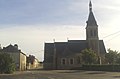
Saint-Sixte Church

lock


literature
- Le Patrimoine des Communes de la Mayenne. Flohic Editions, Volume 2, Paris 2002, ISBN 2-84234-135-X , pp. 784-787.
Web links
Commons : La Chapelle-Rainsouin - Collection of images, videos and audio files