
Saint-Denis-de-Gastines
| Saint-Denis-de-Gastines | ||
|---|---|---|
|
||
| region | Pays de la Loire | |
| Department | Mayenne | |
| Arrondissement | Mayenne | |
| Canton | Ernée | |
| Community association | Ernée | |
| Coordinates | 48 ° 21 ′ N , 0 ° 51 ′ W | |
| height | 128-247 m | |
| surface | 48.01 km 2 | |
| Residents | 1,509 (January 1, 2017) | |
| Population density | 31 inhabitants / km 2 | |
| Post Code | 53500 | |
| INSEE code | 53211 | |
| Website | http://st-denis-de-gastines.fr/ | |

Saint-Denis-de-Gastines is a French commune with 1,509 inhabitants (as of January 1 2017) in the department of Mayenne in the region Pays de la Loire ; it belongs to the arrondissement of Mayenne and the canton of Ernée . The inhabitants are called Dionysia Gastinais .
geography
Saint-Denis-de-Gastines is about 36 kilometers north-northwest of Laval . Saint-Denis-de-Gastines is surrounded by the neighboring communities of Carelles and Colombiers-du-Plessis in the north, Brecé in the north-east, Châtillon-sur-Colmont in the east, Vautorte in the south and south-east, Montenay in the south, Ernée in the south and south-west, Larchamp in the west and Montaudin in the northwest.
Population development
| year | 1962 | 1968 | 1975 | 1982 | 1990 | 1999 | 2006 | 2013 |
| Residents | 1,951 | 2,048 | 1,884 | 1,789 | 1,721 | 1,683 | 1,685 | 1,607 |
| Source: Cassini and INSEE | ||||||||
Attractions
- church
- Montflaux Castle, Monument historique
- Rigardon Castle
- Fumeçon Mill

church
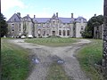
Montflaux Castle
_%C3%89glise_01.JPG)
_Ch%C3%A2teau_de_Montflaux_02.JPG)
Personalities
- Jean-Louis de Fromentières (1632–1684), Bishop of Aire
- Pierre Fauchard (1678–1761), dentist
- Renée-Caroline-Victoire de Froulay (1714–1803), writer
literature
- Le Patrimoine des Communes de la Mayenne. Flohic Editions, Volume 1, Paris 2002, ISBN 2-84234-135-X , pp. 345-348.
Web links
Commons : Saint-Denis-de-Gastines - Collection of images, videos and audio files