
Hambers
| Hambers | ||
|---|---|---|
|
||
| region | Pays de la Loire | |
| Department | Mayenne | |
| Arrondissement | Mayenne | |
| Canton | Evron | |
| Community association | Coëvrons | |
| Coordinates | 48 ° 15 ′ N , 0 ° 25 ′ W | |
| height | 112-291 m | |
| surface | 25.93 km 2 | |
| Residents | 609 (January 1, 2017) | |
| Population density | 23 inhabitants / km 2 | |
| Post Code | 53160 | |
| INSEE code | 53113 | |

Hambers is a French municipality with 609 inhabitants (as of January 1 2017) in Mayenne in the region Pays de la Loire . It belongs to the arrondissement of Mayenne and the canton of Évron (until 2015: canton of Bais ).
geography
Hambers is about 29 kilometers northeast of Laval . Hambers is surrounded by the neighboring communities of La Chapelle-au-Riboul in the north, Champgenéteux in the north and northeast, Bais in the east, Sainte-Gemmes-le-Robert in the southeast, Mézangers in the south, Jublains in the west and Grazay in the northwest.
Population development
| year | 1962 | 1968 | 1975 | 1982 | 1990 | 1999 | 2006 | 2013 |
| Residents | 792 | 707 | 562 | 490 | 451 | 548 | 563 | 636 |
| Source: Cassini and INSEE | ||||||||
Attractions
- Saint-Gervais-Saint-Protais church from the 12th century, monument historique since 1954
- Saint-Michel chapel from 1402 in Le Montaigu
- Saint-Yves chapel from the 20th century
- Chelé castle ruins
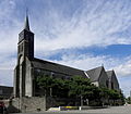
Saint-Gervais-Saint-Protais church

Saint-Michel chapel

Saint-Yves Chapel

Chelé castle ruins
_%C3%89glise_01.JPG)


literature
- Le Patrimoine des Communes de la Mayenne. Flohic Editions, Volume 1, Paris 2002, ISBN 2-84234-135-X , pp. 97-101.
Web links
Commons : Hambers - collection of pictures, videos and audio files