
Couesmes-Vaucé
| Couesmes-Vaucé | ||
|---|---|---|
|
||
| region | Pays de la Loire | |
| Department | Mayenne | |
| Arrondissement | Mayenne | |
| Canton | Gorron | |
| Community association | Bocage Mayennais | |
| Coordinates | 48 ° 27 ′ N , 0 ° 43 ′ W | |
| height | 100-206 m | |
| surface | 19.13 km 2 | |
| Residents | 370 (January 1, 2017) | |
| Population density | 19 inhabitants / km 2 | |
| Post Code | 53300 | |
| INSEE code | 53079 | |

Couesmes-Vaucé is a French municipality with 370 inhabitants (as of January 1 2017) in Mayenne in the region Pays de la Loire ; it belongs to the arrondissement of Mayenne and the canton of Gorron (until 2015: canton of Ambrières-les-Vallées ). The inhabitants are called Couesmiens .
geography
Couesmes-Vaucé is located about 45 kilometers north-northeast of the city center of Laval . Couesmes-Vaucé is surrounded by the neighboring communities of Passais Villages in the north and west, Saint-Fraimbault in the north, Soucé in the northeast, Ceaucé in the east and northeast, Ambrières-les-Vallées in the east and southeast, Le Pas in the south, Brecé in the southwest as well Gorron to the west and south-west.
Population development
| year | 1962 | 1968 | 1975 | 1982 | 1990 | 1999 | 2006 | 2013 |
| Residents | 675 | 618 | 643 | 498 | 451 | 383 | 388 | 396 |
| Source: Cassini and INSEE | ||||||||
Attractions
- Menhir of Montcorbeau, Monument historique
- Saint-Julien-du-Mans church in Couesmes from the 9th / 10th centuries century
- Saint-Pierre church in Vaucé
- Montcorbeau Castle
- ruinous mansion of La Galardière
- Former mill of La Broutière
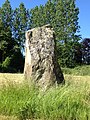
Menhir of Montcorbeau

Saint-Julien-du-Mans church

Saint-Pierre church

Montcorbeau Castle

La Galardière mansion


_%C3%89glise_Saint-Pierre_de_Vauc%C3%A9_02.JPG)


literature
- Le Patrimoine des Communes de la Mayenne. Flohic Editions, Volume 1, Paris 2002, ISBN 2-84234-135-X , pp. 53-55.