Blandouet-Saint Jean
| Blandouet-Saint Jean | ||
|---|---|---|
|
|
||
| region | Pays de la Loire | |
| Department | Mayenne | |
| Arrondissement | Mayenne | |
| Canton | Meslay-du-Maine | |
| Community association | Coëvrons | |
| Coordinates | 48 ° 2 ′ N , 0 ° 24 ′ W | |
| height | 58–225 m | |
| surface | 36.72 km 2 | |
| Residents | 605 (January 1, 2017) | |
| Population density | 16 inhabitants / km 2 | |
| Post Code | 53270 | |
| INSEE code | 53228 | |
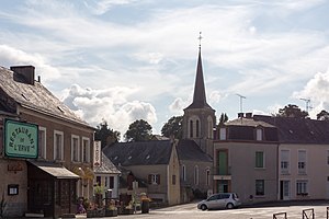
 View of the center of Saint-Jean-sur-Erve |
||
Blandouet-Saint Jean is a French municipality with 605 inhabitants (as of January 1 2017) in the department of Mayenne in the region Pays de la Loire . It belongs to the arrondissement of Mayenne and the canton of Meslay-du-Maine .
Geographical location
Blandouet-Saint Jean is about 40 kilometers west of Le Mans on the Erve . Blandouet-Saint Jean is surrounded by the neighboring communities of Sainte-Suzanne-et-Chammes in the north, Torcé-Viviers-en-Charnie in the northeast, Saint-Denis-d'Orques in the east and southeast, Thorigné-en-Charnie and Saint-Pierre -sur-Erve in the south and Vaiges in the west.
history
On January 1, 2017, the municipality was formed as Commune nouvelle from the previously independent municipalities of Blandouet and Saint-Jean-sur-Erve .
structure
| District | former INSEE code |
Area (km²) | Population (2016) |
|---|---|---|---|
| Saint-Jean-sur-Erve (administrative headquarters) | 53228 | 25.39 | 427 |
| Blandouet | 53032 | 11.33 | 189 |
Web links
Individual evidence
- ↑ Population figures retrospectively from January 1, 2016
