
Moulay
| Moulay | ||
|---|---|---|
|
||
| region | Pays de la Loire | |
| Department | Mayenne | |
| Arrondissement | Mayenne | |
| Canton | Lassay-les-Châteaux | |
| Community association | Mayenne Community | |
| Coordinates | 48 ° 16 ′ N , 0 ° 38 ′ W | |
| height | 80-138 m | |
| surface | 8.66 km 2 | |
| Residents | 963 (January 1, 2017) | |
| Population density | 111 inhabitants / km 2 | |
| Post Code | 53100 | |
| INSEE code | 53162 | |

Moulay is a French municipality with 963 inhabitants (as of January 1 2017) in Mayenne in the region Pays de la Loire ; it belongs to the arrondissement Mayenne and the canton Lassay-les-Châteaux (until 2015: canton Mayenne-Est ). The inhabitants are called Moulaisiens .
geography
Moulay is located about 19 kilometers north-northeast of the city center of Laval am Mayenne , which borders the municipality to the north and west and into which the Aron flows here. Moulay is surrounded by the neighboring communities of Mayenne in the north, La Bazoge-Montpinçon in the east and north-east, Belgeard in the east and south-east, Commer in the south, Contest in the west and south-west and Saint-Baudelle in the west and north-west.
Population development
| year | 1962 | 1968 | 1975 | 1982 | 1990 | 1999 | 2006 | 2013 |
| Residents | 316 | 297 | 605 | 883 | 919 | 907 | 922 | 972 |
| Source: Cassini and INSEE | ||||||||
Attractions
- Gallic oppidum, around 100 BC, since 1986 the archaeological site of Monument historique
- Saint-Martin church from the 12th century
- Le Bas Mont castle from the 17th century
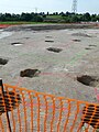
Remnants of the Moulay oppidum

Saint Martin Church


literature
- Le Patrimoine des Communes de la Mayenne. Flohic Editions, Volume 2, Paris 2002, ISBN 2-84234-135-X , pp. 718-720.
Web links