
Cheers
| Cheers | ||
|---|---|---|
|
||
| region | Pays de la Loire | |
| Department | Mayenne | |
| Arrondissement | Mayenne | |
| Canton | Lassay-les-Châteaux | |
| Community association | Mayenne Community | |
| Coordinates | 48 ° 15 ′ N , 0 ° 30 ′ W | |
| height | 104-190 m | |
| surface | 36.01 km 2 | |
| Residents | 734 (January 1, 2017) | |
| Population density | 20 inhabitants / km 2 | |
| Post Code | 53160 | |
| INSEE code | 53122 | |
 Defensive wall, behind it the church tower |
||

Jublains , formerly Jubleins , is a French municipality with 734 inhabitants (at January 1, 2017) in the department of Mayenne in the region Pays de la Loire . It belongs to the canton of Lassay-les-Châteaux (until 2015: canton of Bais ).
history
Jublains is the old Noviodunum (also Noeodunum or Noiodunum ; Greek Νοιόδουνον ), the capital of the Gallic Celtic tribe of the Diablints . After the Roman conquest and settlement, it was called Civitas Diablintum . A museum and excavations around the Roman theater document the ancient history of the place.
In a document from the Middle Ages referred to by the geographer Jean-Baptiste Bourguignon d'Anville , the name Jublent first appeared, which was later changed to Jubleins . A Roman road map names a main town Nudionnum between Araegenus ( Vieux in the Calvados department ) and Subdinnum ( Le Mans ), probably meaning Noeodunum .
Jublains is part of the Pays d'art et d'histoire Coëvrons-Mayenne , together with Mayenne , Évron , Sainte-Suzanne and Saulges .
Population development
| year | 1968 | 1975 | 1982 | 1990 | 1999 | 2010 |
| Residents | 918 | 761 | 731 | 718 | 699 | 682 |
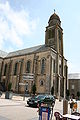
church

museum

Roman theater


literature
- Le Patrimoine des Communes de la Mayenne. Flohic Editions, Volume 1, Paris 2002, ISBN 2-84234-135-X , pp. 104-109.
Web links
- Community website (accessed November 4, 2013)
- Map and information (accessed November 4, 2013)
- Museum and Archeology Park (accessed November 4, 2013)
- Roman theater (accessed November 4, 2013)