
Saint-Aubin-Fosse-Louvain
| Saint-Aubin-Fosse-Louvain | ||
|---|---|---|
|
||
| region | Pays de la Loire | |
| Department | Mayenne | |
| Arrondissement | Mayenne | |
| Canton | Gorron | |
| Community association | Bocage Mayennais | |
| Coordinates | 48 ° 28 ′ N , 0 ° 50 ′ W | |
| height | 153-207 m | |
| surface | 14.37 km 2 | |
| Residents | 217 (January 1, 2017) | |
| Population density | 15 inhabitants / km 2 | |
| Post Code | 53120 | |
| INSEE code | 53199 | |
_Mairie.JPG) Town hall (Mairie) of Saint-Aubin-Fosse-Louvain |
||

Saint-Aubin-Fosse-Louvain is a French municipality with 217 inhabitants (as of January 1 2017) in Mayenne in the region Pays de la Loire ; it belongs to the arrondissement of Mayenne and the canton of Gorron . The inhabitants are called Saint-Aubinois .
geography
Saint-Aubin-Fosse-Louvain is about 55 kilometers north of Laval city center . Saint-Aubin-Fosse-Louvain is surrounded by the neighboring communities of Désertines in the north and north-west, Passais-Villages in the north-east, Lesbois in the east, Gorron in the south and south-east, Hercé in the south and south-west and Vieuvy in the west.
Population development
| year | 1962 | 1968 | 1975 | 1982 | 1990 | 1999 | 2006 | 2013 |
| Residents | 540 | 454 | 393 | 324 | 290 | 252 | 277 | 230 |
| Source: Cassini and INSEE | ||||||||
Attractions
- Saint-Aubin church from the 15th century
- La Cour mansion
- English tower
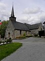
Saint-Aubin church

La Cour mansion

English tower
_%C3%89glise_02.JPG)
_Manoir_de_La_Cour.JPG)

literature
- Le Patrimoine des Communes de la Mayenne. Flohic Editions, Volume 1, Paris 2002, ISBN 2-84234-135-X , pp. 397-399.
Web links
Commons : Saint-Aubin-Fosse-Louvain - Collection of images, videos and audio files