
Ernée
| Ernée | ||
|---|---|---|

|
|
|
| region | Pays de la Loire | |
| Department | Mayenne | |
| Arrondissement | Mayenne | |
| Canton | Ernée (main town) | |
| Community association | Ernée | |
| Coordinates | 48 ° 18 ′ N , 0 ° 56 ′ W | |
| height | 107-200 m | |
| surface | 36.53 km 2 | |
| Residents | 5,731 (January 1, 2017) | |
| Population density | 157 inhabitants / km 2 | |
| Post Code | 53500 | |
| INSEE code | 53096 | |
| Website | www.ville-ernee.fr | |

Ernée is a French municipality with 5731 inhabitants (at January 1, 2017) in the department of Mayenne in the region Pays de la Loire . It is crossed by the river Ernée of the same name .
History and important buildings
In the municipality there are historical sites such as the Dolmen Contrie du Rocher , north of Ernée, the Allée couverte de la Tardivière and Roman sites, which are presented in a museum.
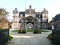
Ernée owns the Chapelle de Charné , a chapel from the 12th century and the Château de Pannard , a Renaissance castle from the 16th century.
Twin cities
- Glenfield ( United Kingdom )
- Dorsten ( Germany )
- Plénée-Jugon


.jpg)


Personalities
- Philippe Tesnière (1955–1987), cyclist
literature
- René Delaunay: Histoire de la ville et du pays d'Ernée. Reprinted by Joseph Floc'h, Mayenne 1974.
- Le Patrimoine des Communes de la Mayenne. Flohic Editions, Volume 1, Paris 2002, ISBN 2-84234-135-X , pp. 335-340.
Web links
Commons : Ernée - collection of images, videos and audio files