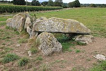
Allée couverte de la Tardivière
The Allée couverte de la Tardivière is about 200 meters east of the D220 (from Ernée to Carelles ), next to the road that leads to the farm of Tardivière in Ernée in the Mayenne department in France .
De la Tardivière is a west-east oriented small allée couverte in a ruinous condition from 6.0 to 7.0 meters in length, on a slight slope. It has eight pairs of lateral bearing stones and an end stone at the top. A large stone is the only surviving capstone at the lower, western end.
On the western side of the D220 is the Dolmen Contrie du Rocher about 250 m away .
- Allée couverte de la Tardivière
literature
- Pierre-Roland Giot: Circonscription de Rennes In: Gallia Préhistoire, CNRS, Volume 5, no 1, 1962, pp. 187-201 ISSN 0016-4119.
- Jürgen E. Walkowitz: The megalithic syndrome. European cult sites of the Stone Age (= contributions to the prehistory and early history of Central Europe. Vol. 36). Beier & Beran, Langenweißbach 2003, ISBN 3-930036-70-3 .
Web links
Commons : Allée couverte de la Tardivière - Collection of images, videos and audio files
Coordinates: 48 ° 19 ′ 43.7 " N , 0 ° 54 ′ 51.5" W.


