
Landivy
| Landivy | ||
|---|---|---|

|
|
|
| region | Pays de la Loire | |
| Department | Mayenne | |
| Arrondissement | Mayenne | |
| Canton | Gorron | |
| Community association | Bocage Mayennais | |
| Coordinates | 48 ° 29 ′ N , 1 ° 2 ′ W | |
| height | 92-231 m | |
| surface | 28.54 km 2 | |
| Residents | 1,149 (January 1, 2017) | |
| Population density | 40 inhabitants / km 2 | |
| Post Code | 53190 | |
| INSEE code | 53125 | |
| Website | http://www.landivy.fr/ | |
 Landivy Town Hall (Mairie) |
||

Landivy is a French commune with 1,149 inhabitants (as of January 1 2017) in Mayenne in the region Pays de la Loire . It belongs to the arrondissement of Mayenne and the canton of Gorron (until 2015: canton of Landivy ). The inhabitants are called Landivysia .
geography
Landivy is about 52 kilometers northeast of Rennes . Landivy is surrounded by the neighboring communities Savigny-le-Vieux in the north, Buais-Les-Monts with Buais in the northeast, Fougerolles-du-Plessis in the east, La Dorée in the southeast, Saint-Mars-sur-la-Futaie in the south, and Pontmain in the south and south-west, La Bazouge-du-Désert in the south-west, Louvigné-du-Désert in the west and Les Loges-Marchis in the north-west.
Population development
| year | 1962 | 1968 | 1975 | 1982 | 1990 | 1999 | 2006 | 2013 |
| Residents | 1,565 | 1,525 | 1,473 | 1,456 | 1,391 | 1,286 | 1,212 | 1,156 |
| Source: Cassini and INSEE | ||||||||
Attractions
- 19th century Saint Martin church
- Chapel of Le Pont-Aubray from the 14th century, Monument historique
- Mausson Castle from the 15th / 16th centuries Century, Monument historique since 1912
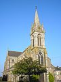
Saint Martin Church
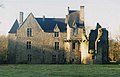
Mausson Castle


literature
- Le Patrimoine des Communes de la Mayenne. Flohic Editions, Volume 2, Paris 2002, ISBN 2-84234-135-X , pp. 502-505.
Web links
Commons : Landivy - collection of images, videos and audio files