
La Bazouge-du-Désert
| La Bazouge-du-Désert | ||
|---|---|---|
.svg)
|
|
|
| region | Brittany | |
| Department | Ille-et-Vilaine | |
| Arrondissement | Fougères-Vitré | |
| Canton | Fougères-2 | |
| Community association | Fougères agglomeration | |
| Coordinates | 48 ° 27 ′ N , 1 ° 6 ′ W | |
| height | 113-193 m | |
| surface | 24.60 km 2 | |
| Residents | 1,087 (January 1, 2017) | |
| Population density | 44 inhabitants / km 2 | |
| Post Code | 35420 | |
| INSEE code | 35018 | |
_Mairie.jpg) Mairie La Bazouge-du-Désert |
||

La Bazouge-du-Désert , in Breton Bazaleg-an-Dezerzh , on Gallo La Bazòj-deü-Dezèrt , is a municipality in the French department of Ille-et-Vilaine in Brittany . It belongs to the canton of Fougères-2 (until 2015 canton of Louvigné-du-Désert ) in the arrondissement of Fougères-Vitré . It is bordered by Louvigné-du-Désert to the north, Landivy to the northeast, Pontmain to the east, Saint-Ellier-du-Maine to the southeast, and Landéan to the south and west .
Population development
| year | 1962 | 1968 | 1975 | 1982 | 1990 | 1999 | 2008 | 2013 |
|---|---|---|---|---|---|---|---|---|
| Residents | 1,399 | 1,340 | 1,280 | 1,158 | 1,074 | 1.012 | 1,053 | 1.110 |
Attractions
- Saint Martin Church
- Former sentry
- Floor cross

Saint Martin Church

House dating from 1716 and used as a guard during the Battle of La Bazouge-du-Désert
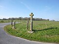
Floor cross
_%C3%89glise_05.JPG)
_Malagra_05.JPG)

literature
- Le Patrimoine des Communes d'Ille-et-Vilaine. Flohic Editions, Volume 1, Paris 2000, ISBN 2-84234-072-8 , pp. 823-824.
Web links
Commons : La Bazouge-du-Désert - Collection of images, videos and audio files