
Le Châtellier (Ille-et-Vilaine)
|
Le Châtellier Kasteller |
||
|---|---|---|
.svg)
|
|
|
| region | Brittany | |
| Department | Ille-et-Vilaine | |
| Arrondissement | Fougères-Vitré | |
| Canton | Antrain | |
| Community association | Couesnon Marches de Bretagne | |
| Coordinates | 48 ° 25 ′ N , 1 ° 15 ′ W | |
| height | 113-183 m | |
| surface | 13.43 km 2 | |
| Residents | 427 (January 1, 2017) | |
| Population density | 32 inhabitants / km 2 | |
| Post Code | 35133 | |
| INSEE code | 35071 | |
_Mairie.jpg) Le Châtellier Town Hall |
||

Le Châtellier ( Breton : Kasteller ; Gallo : Le CHASTELIER ) is a French municipality with 427 inhabitants (as of January 1 2017) in the department of Ille-et-Vilaine in the region of Brittany . The municipality belongs to the arrondissement Fougères-Vitré and the canton Antrain (until 2015: canton Saint-Brice-en-Coglès ). The inhabitants are called Castellérois or Castellégiens .
geography
Le Châtellier is about 46 km northeast of Rennes . The Beuvron river has its source on the eastern border of the municipality. Le Châtellier is surrounded by the neighboring communities of Poilley in the north, Villamée in the northeast, Parigné in the east, Saint-Germain-en-Coglès in the south and west and Montours in the north-west.
history
On July 12, 1794, a skirmish took place here during the so-called Chouannerie between the royalist insurgents and republican troops who had moved into the town, which ended in their favor despite the numerical inferiority of the republicans. The place was not insignificantly affected.
Population development
| 1962 | 1968 | 1975 | 1982 | 1990 | 1999 | 2006 | 2012 |
|---|---|---|---|---|---|---|---|
| 562 | 501 | 444 | 407 | 407 | 393 | 386 | 376 |
| Source: Cassini and INSEE | |||||||
Attractions
- Notre-Dame Church, 1849 to 1853
- La Vieuville Castle, part of the wall has been a monument historique since 1946
- Rock formation
- Upper Brittany Botanical Garden

Notre-Dame church

La Vieuville Castle
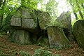
Rock formation

Botanical garden (here: garden of the rising sun)
_Eglise.jpg)
_Ch%C3%A2teau_de_La_Vieuville_02.jpg)


literature
- Le Patrimoine des Communes d'Ille-et-Vilaine. Flohic Editions, Volume 2, Paris 2000, ISBN 2-84234-072-8 , pp. 1438-1445.