
Marcillé-Robert
|
Marcillé-Robert Marc'helleg-Roperzh |
||
|---|---|---|
.svg)
|
|
|
| region | Brittany | |
| Department | Ille-et-Vilaine | |
| Arrondissement | Fougères-Vitré | |
| Canton | La Guerche-de-Bretagne | |
| Community association | Pays de la Roche aux Fées | |
| Coordinates | 47 ° 57 ′ N , 1 ° 22 ′ W | |
| height | 37-87 m | |
| surface | 20.3 km 2 | |
| Residents | 959 (January 1, 2017) | |
| Population density | 47 inhabitants / km 2 | |
| Post Code | 35240 | |
| INSEE code | 35165 | |

Marcillé-Robert ( Breton : Marc'helleg-Roperzh , Gallo : Marcilhae-Robèrt ) is a French municipality with 959 inhabitants (as of January 1 2017) in the department of Ille-et-Vilaine in the region of Brittany ; it belongs to the Arrondissement Fougères-Vitré and is part of the canton of La Guerche-de-Bretagne (until 2015: canton of Retiers ). The inhabitants are called Marcilléens .
geography
Marcillé-Robert is located about 29 kilometers southeast of Rennes . The confluence of the Seiche and Ardenne rivers form the Lake Marcillé (Étang de Marcillé) . Marcillé-Robert is surrounded by the neighboring communities of Moulins in the north, Bais in the northeast, Visseiche in the east, Retiers in the south, Le Theil-de-Bretagne in the southwest, Essé in the west and Boistrudan in the west and northwest.
Population development
| year | 1962 | 1968 | 1975 | 1982 | 1990 | 1999 | 2006 | 2013 |
| Residents | 1,048 | 983 | 943 | 837 | 837 | 856 | 922 | 973 |
|
Source: INSEE
|
||||||||
Attractions
See also: List of Monuments historiques in Marcillé-Robert
- Saint-Ouen church with pulpit ( Monument historique )
- Castle ruins
- 19th century castle
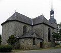
Saint-Ouen church

View of the castle and church
_%C3%89glise_Saint-Ouen_01.jpg)

Personalities
- Auguste Pavie (1847–1925), explorer and diplomat
literature
- Le Patrimoine des Communes d'Ille-et-Vilaine. Flohic Editions, Volume 2, Paris 2000, ISBN 2-84234-072-8 , pp. 1323-1326.