
Le Theil-de-Bretagne
|
Le Theil-de-Bretagne To Tilh |
||
|---|---|---|
|
||
| region | Brittany | |
| Department | Ille-et-Vilaine | |
| Arrondissement | Fougères-Vitré | |
| Canton | La Guerche-de-Bretagne | |
| Community association | Pays de la Roche aux Fées | |
| Coordinates | 47 ° 55 ′ N , 1 ° 26 ′ W | |
| height | 42-106 m | |
| surface | 24.2 km 2 | |
| Residents | 1,734 (January 1, 2017) | |
| Population density | 72 inhabitants / km 2 | |
| Post Code | 35240 | |
| INSEE code | 35333 | |
| Website | http://letheildebretagne.fr/ | |
_Mairie.jpg) Town hall (Mairie) of Le Theil-de-Bretagne |
||

Le Theil-de-Bretagne ( Breton : An Tilh , Gallo : Le Teilh ) is a French municipality with 1734 inhabitants (as of January 1 2017) in the department of Ille-et-Vilaine in the region of Brittany ; it belongs to the Arrondissement Fougères-Vitré and is part of the canton of La Guerche-de-Bretagne (until 2015: canton of Retiers ). The inhabitants are called Theillais .
geography
Le Theil-de-Bretagne is located about 28 kilometers south-east of Rennes . Le Theil-de-Bretagne is surrounded by the neighboring communities of Essé in the north, Marcillé-Robert in the northeast, Retiers in the east, Coësmes in the south, Sainte-Colombe in the southwest and Janzé in the west.
The place has a train station on the Châteaubriant – Rennes railway line .
Population development
| year | 1962 | 1968 | 1975 | 1982 | 1990 | 1999 | 2006 | 2013 |
| Residents | 1,018 | 1,016 | 1,089 | 1,133 | 1,123 | 1,130 | 1,445 | 1,706 |
|
Source: INSEE
|
||||||||
Attractions
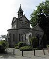
- Saint-Maimboeuf church
- Notre-Dame chapel in Beauvais, Monument historique since 2013
- La Rigaudière castle from the 17th century
- The Rumfort menhirs are located in the forest south of Le Theil-de-Bretagne

Saint-Maimboeuf church
Notre-Dame chapel
_%C3%89glise_Saint-Maimb%C5%93uf_Ext%C3%A9rieur_01.jpg)
_Chapelle_ND_de_Beauvais_01.jpg)
literature
- Le Patrimoine des Communes d'Ille-et-Vilaine. Flohic Editions, Volume 2, Paris 2000, ISBN 2-84234-072-8 , pp. 1338-1342.