Retiers
|
Retiers Rester |
||
|---|---|---|

|
|
|
| region | Brittany | |
| Department | Ille-et-Vilaine | |
| Arrondissement | Fougères-Vitré | |
| Canton | La Guerche-de-Bretagne | |
| Community association | Pays de la Roche aux Fées | |
| Coordinates | 47 ° 55 ' N , 1 ° 23' W | |
| height | 41-120 m | |
| surface | 41.38 km 2 | |
| Residents | 4,357 (January 1, 2017) | |
| Population density | 105 inhabitants / km 2 | |
| Post Code | 35240 | |
| INSEE code | 35239 | |
| Website | http://www.retiers.fr/ | |
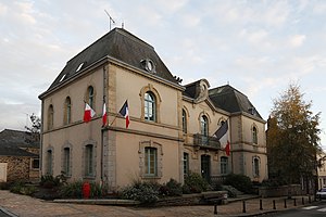
 Retiers Town Hall |
||
Retiers ( Breton : Rester ) is a French municipality with 4357 inhabitants (as of January 1 2017) in the department of Ille-et-Vilaine in the region of Brittany ; it belongs to the Arrondissement Fougères-Vitré and the canton of La Guerche-de-Bretagne . The inhabitants are called Restériens .
geography
The Ardenne flows through the municipality of Retiers . Retiers is surrounded by the neighboring communities Marcillé-Robert in the north, Visseiche , Arbrissel and Moussé in the northeast, Drouges and Rannée in the east, Forges-la-Forêt in the southeast, Martigné-Ferchaud in the south, Coësmes in the southwest and Le Theil-de-Bretagne in the north and northwest. To the east of the municipality is the Forêt de la Guerche .
The place has a train station on the Châteaubriant – Rennes railway line .
history
The dolmens as evidence of earlier settlement of the municipality are dated to the Bronze Age around 2000 to 2500 BC.
Population development
| year | 1962 | 1968 | 1975 | 1982 | 1990 | 1999 | 2006 | 2011 |
| Residents | 2,878 | 3,153 | 3,331 | 3,431 | 3,306 | 3,212 | 3,530 | 3,876 |
|
Source: INSEE
|
||||||||
Attractions
- Richebourg Stone ( Monument historique )
- Saint-Pierre church and square, rebuilt in the 17th century
Community partnerships
There is a partnership with the Polish municipality of Mieścisko in Greater Poland .
literature
- Le Patrimoine des Communes d'Ille-et-Vilaine. Flohic Editions, Volume 2, Paris 2000, ISBN 2-84234-072-8 , pp. 1333-1336.


