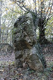
Pierre de Richebourg
The Neolithic menhir Pierre de Richebourg , (also known as menhir de Richebourg), is southeast of the village Retiers west of the forest of Guerche, near the intersection of department road D 41 and D 310 southeast of Rennes in the Ille-et-Vilaine in Brittany in France .
The menhir consists of a local block of quartzite (silicate sandstone ). As early as 1888, the Prefect of Vitré took measures to preserve the menhir. It is already mentioned in the "Guides Joanne" from 1853 - the ancestors of the "Guides bleus" from 1916 and has been classified as a Monument historique since 1977 .
It is oriented east-west and has a rectangular shape, with a height of about 3.0 meters, a width of 2.35 meters and a thickness of 1.5 meters. It is said that he has a handprint on the upper part.
See also
literature
- Jacques Briard : The Megaliths of Brittany. Editions Gisserot 2000, ISBN 2-87747-065-2 , p. 32.
- Pierre-Roland Giot : La Bretagne des mégalithes , Ouest-France, coll. "Itinéraires de découvertes", 2014, ISBN 978-2-7373-6233-0 .
Web links
Individual evidence
- ↑ The Guides bleus are the oldest collection of French travel guides published by Hachette Livre.
Coordinates: 47 ° 52 ′ 55.2 " N , 1 ° 19 ′ 24.2" W.

