
Montreuil-sous-Pérouse
| Montreuil-sous-Pérouse | ||
|---|---|---|
|
||
| region | Brittany | |
| Department | Ille-et-Vilaine | |
| Arrondissement | Fougères-Vitré | |
| Canton | Vitré | |
| Community association | Vitré Communauté | |
| Coordinates | 48 ° 9 ′ N , 1 ° 14 ′ W | |
| height | 53-125 m | |
| surface | 15.49 km 2 | |
| Residents | 1,015 (January 1, 2017) | |
| Population density | 66 inhabitants / km 2 | |
| Post Code | 35500 | |
| INSEE code | 35194 | |

Montreuil-sous-Pérouse is a commune in the French department of Ille-et-Vilaine in Brittany . It belongs to the canton of Vitré in the arrondissement of Fougères-Vitré . It borders on Taillis to the north, Balazé to the east, Vitré to the south, Pocé-les-Bois and Champeaux to the southwest, and Landavran to the northwest . The Cantache , a tributary of the Vilaine , passes Montreuil-sous-Pérouse and forms the lake called Étang de la Cantache on the western municipal boundary . This also takes in the river Pérouse .
Population development
| year | 1962 | 1968 | 1975 | 1982 | 1990 | 1999 | 2006 | 2013 |
|---|---|---|---|---|---|---|---|---|
| Residents | 505 | 509 | 559 | 798 | 889 | 928 | 1,027 | 1,029 |
Attractions
- Saint-Pierre et Saint-Paul church
- Chapel Pérouse
- War memorial
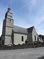
Saint-Pierre et Saint-Paul church
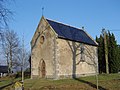
La Chapelle de Pérouse
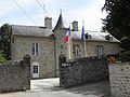
Mairie Montreuil-sous-Pérouse

The river Pérouse
_%C3%89glise_01.jpg)

_Mairie.jpg)

literature
- Le Patrimoine des Communes d'Ille-et-Vilaine. Flohic Editions, Volume 2, Paris 2000, ISBN 2-84234-072-8 , pp. 1706-1710.
Web links
Commons : Montreuil-sous-Pérouse - Collection of images, videos and audio files