
Saint-Didier (Ille-et-Vilaine)
|
Saint-Didier Sant-Ider |
||
|---|---|---|

|
|
|
| region | Brittany | |
| Department | Ille-et-Vilaine | |
| Arrondissement | Fougères-Vitré | |
| Canton | Chateaugiron | |
| Community association | Vitré Communauté | |
| Coordinates | 48 ° 6 ′ N , 1 ° 22 ′ W | |
| height | 40-97 m | |
| surface | 14.14 km 2 | |
| Residents | 2,052 (January 1, 2017) | |
| Population density | 145 inhabitants / km 2 | |
| Post Code | 35220 | |
| INSEE code | 35264 | |
| Website | http://www.saintdidier35.fr/ | |
_-_mairie.jpg) Town hall (Mairie) of Saint-Didier |
||

Saint-Didier ( Breton: Sant-Ider ; Gallo : Saent-Didier ) is a French municipality with 2052 inhabitants (as of January 1 2017) in the department of Ille-et-Vilaine in the region of Brittany ; it belongs to the Arrondissement Fougères-Vitré and the canton of Châteaugiron (until 2015: canton of Châteaubourg ). The inhabitants are called Déodatiens .
geography
Saint-Didier is about 23 kilometers east of Rennes . The Vilaine limits the municipality to the north. Saint-Didier is surrounded by the neighboring communities of Saint-Jean-sur-Vilaine in the north, Cornillé in the east, Louvigné-de-Bais in the south and south-east, Domagné in the west and south-west and Châteaubourg in the west and north-west.
The national route 157 runs through the municipality .
Population development
| year | 1962 | 1968 | 1975 | 1982 | 1990 | 1999 | 2006 | 2013 |
| Residents | 679 | 652 | 679 | 859 | 1,055 | 1,275 | 1,590 | 1.919 |
| Source: Cassini and INSEE | ||||||||
Attractions
See also: List of Monuments historiques in Saint-Didier (Ille-et-Vilaine)
- Saint-Didier-et-Saint-Golven church
- Notre-Dame-de-la-Peinière chapel from the 19th century
- Saint-Trottin Chapel
- La Morandière Castle
- Fouesnel manor
- Saud-Cour mansion
- La Touche mansion
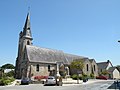
Saint-Didier-et-Saint-Golven church

Notre-Dame-de-la-Peinière chapel
_-_%C3%A9glise.jpg)
_La_Peini%C3%A8re_03.jpg)
literature
- Le Patrimoine des Communes d'Ille-et-Vilaine. Flohic Editions, Volume 1, Paris 2000, ISBN 2-84234-072-8 , pp. 342-345.