
Cornillé
|
Cornillé Kornilieg |
||
|---|---|---|
.svg)
|
|
|
| region | Brittany | |
| Department | Ille-et-Vilaine | |
| Arrondissement | Fougères-Vitré | |
| Canton | Vitré | |
| Community association | Vitré Communauté | |
| Coordinates | 48 ° 5 ′ N , 1 ° 18 ′ W | |
| height | 45-107 m | |
| surface | 12.47 km 2 | |
| Residents | 966 (January 1, 2017) | |
| Population density | 77 inhabitants / km 2 | |
| Post Code | 35500 | |
| INSEE code | 35087 | |
| Website | http://mairiecornille.e-monsite.com/ | |
 Town hall (Mairie) of Cornillé |
||

Cornillé ( Breton : Kornilieg ) is a French municipality with 966 inhabitants (as of January 1 2017) in the department of Ille-et-Vilaine in the region of Brittany ; it belongs to the Arrondissement Fougères-Vitré and the canton Vitré (until 2015: canton Vitré-Ouest ). The inhabitants are called Cornilléens .
geography
Cornillé is 28 kilometers east-northeast of Rennes . Cornillé is surrounded by the neighboring communities of Saint-Jean-sur-Vilaine in the north and north-west, Saint-Aubin-des-Landes in the east and north-east, Torcé in the south and south-east, Louvigné-de-Bais in the south and south-west and Saint-Didier in the West.
The national route 157 runs through the municipality .
Population development
| year | 1962 | 1968 | 1975 | 1982 | 1990 | 1999 | 2006 | 2017 |
| Residents | 580 | 555 | 524 | 532 | 572 | 663 | 846 | 966 |
| Sources: Cassini and INSEE | ||||||||
Attractions
- Saint-Melaine church from the 15th century
- Rectory
- La Bichetière Castle, built in 1857, with a chapel

Saint-Melaine church
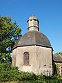
Chapel at La Bichetière Castle


literature
- Le Patrimoine des Communes d'Ille-et-Vilaine. Flohic Editions, Volume 2, Paris 2000, ISBN 2-84234-072-8 , pp. 1694–1695.
Web links
Commons : Cornillé - collection of images, videos and audio files