
Chantrigné
| Chantrigné | ||
|---|---|---|
|
||
| region | Pays de la Loire | |
| Department | Mayenne | |
| Arrondissement | Mayenne | |
| Canton | Gorron | |
| Community association | Bocage Mayennais | |
| Coordinates | 48 ° 25 ′ N , 0 ° 34 ′ W | |
| height | 97-285 m | |
| surface | 18.62 km 2 | |
| Residents | 618 (January 1, 2017) | |
| Population density | 33 inhabitants / km 2 | |
| Post Code | 53300 | |
| INSEE code | 53055 | |
| Website | http://www.chantrigne.mairie53.fr/ | |

Chantrigné is a French municipality with 618 inhabitants (as of January 1 2017) in Mayenne in the region Pays de la Loire ; it belongs to the arrondissement of Mayenne and the canton of Gorron (until 2015: canton of Ambrières-les-Vallées ). The inhabitants are called Chantrignéens .
geography
Chantrigné is located about 46 kilometers north-northeast of the city center of Laval . Chantrigné is surrounded by the neighboring communities of Ambrières-les-Vallées in the north and west, Lassay-les-Châteaux in the north and east, Le Horps in the south-east, and Montreuil-Poulay and Saint-Loup-du-Gast in the south.
Population development
| year | 1962 | 1968 | 1975 | 1982 | 1990 | 1999 | 2006 | 2013 |
| Residents | 720 | 731 | 651 | 606 | 594 | 588 | 609 | 608 |
| Source: Cassini and INSEE | ||||||||
Attractions
- Menhir from Le Grand Coudray, Monument historique since 1976
- Allée couverte de la Hameliniere , Monument historique since 1932
- Saint-Pierre-Saint-Paul Church
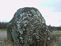
Menhir Le Grand Coudray
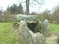
Allée couverte by La Hamelinière

Saint-Pierre-Saint-Paul Church


literature
- Le Patrimoine des Communes de la Mayenne. Flohic Editions, Volume 1, Paris 2002, ISBN 2-84234-135-X , pp. 51-53.
Web links
Commons : Chantrigné - collection of images, videos and audio files