Hercé
| Hercé | ||
|---|---|---|

|
|
|
| region | Pays de la Loire | |
| Department | Mayenne | |
| Arrondissement | Mayenne | |
| Canton | Gorron | |
| Community association | Bocage Mayennais | |
| Coordinates | 48 ° 25 ′ N , 0 ° 51 ′ W | |
| height | 154-242 m | |
| surface | 10.2 km 2 | |
| Residents | 312 (January 1, 2017) | |
| Population density | 31 inhabitants / km 2 | |
| Post Code | 53120 | |
| INSEE code | 53115 | |
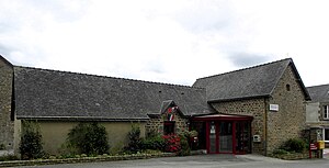
 Town hall (Mairie) of Hercé |
||
Hercé is a French municipality with 312 inhabitants (as of January 1 2017) in Mayenne in the region Pays de la Loire ; it belongs to the arrondissement of Mayenne and the canton of Gorron . The inhabitants are called Hercéens .
geography
Hercé is about 38 kilometers north-northwest of Laval city center . Hercé is surrounded by the neighboring municipalities of Vieuvy in the north and north-west, Saint-Aubin-Fosse-Louvain in the north and north-east, Gorron in the east, Colombiers-du-Plessis in the south, Carelles in the south-west and Levaré in the west.
Population development
| year | 1962 | 1968 | 1975 | 1982 | 1990 | 1999 | 2006 | 2013 |
| Residents | 436 | 408 | 371 | 347 | 328 | 335 | 327 | 321 |
| Source: Cassini and INSEE | ||||||||
Attractions
- Dolmen
- 15th century church L'Immaculée-Conception
- Le Bailleul castles
literature
- Le Patrimoine des Communes de la Mayenne. Flohic Editions, Volume 1, Paris 2002, ISBN 2-84234-135-X , p. 394.
Web links
Commons : Hercé - collection of images, videos and audio files

