
Montreuil-Poulay
| Montreuil-Poulay | ||
|---|---|---|
|
||
| region | Pays de la Loire | |
| Department | Mayenne | |
| Arrondissement | Mayenne | |
| Canton | Lassay-les-Châteaux | |
| Community association | Mayenne Community | |
| Coordinates | 48 ° 23 ′ N , 0 ° 31 ′ W | |
| height | 119-296 m | |
| surface | 16.24 km 2 | |
| Residents | 371 (January 1, 2017) | |
| Population density | 23 inhabitants / km 2 | |
| Post Code | 53640 | |
| INSEE code | 53160 | |

Montreuil-Poulay is a French municipality with 371 inhabitants (as of January 1 2017) in Mayenne in the region Pays de la Loire . The municipality belongs to the canton of Lassay-les-Châteaux (until 2015: canton of Le Horps ) and the arrondissement of Mayenne . The inhabitants are called Montreuillois-Pauliaciens .
geography
Montreuil-Poulay is located about 38 kilometers north-northeast of Laval . Montreuil-Poulay is surrounded by the neighboring communities of Chantrigné in the north and north-west, Le Horps in the east, Champéon in the south and south-east, Saint-Fraimbault-de-Prières in the south-west and Saint-Loup-du-Gast in the west.
Population development
| year | 1962 | 1968 | 1975 | 1982 | 1990 | 1999 | 2006 | 2013 |
| Residents | 330 | 270 | 416 | 401 | 364 | 414 | 404 | 399 |
Attractions
- Saint Martin Church in Montreuil
- Saint-Pierre-et-Saint-Paul church in Poulay
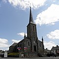
Saint Martin Church

Saint-Pierre-et-Saint-Paul church
_%C3%89glise_Saint-Martin_de_Montreuil_01.JPG)
_%C3%89glise.JPG)
literature
- Le Patrimoine des Communes de la Mayenne. Flohic Editions, Volume 1, Paris 2002, ISBN 2-84234-135-X , pp. 445-449.
Web links
Commons : Montreuil-Poulay - collection of images, videos and audio files