
Ceaucé
| Ceaucé | ||
|---|---|---|
|
||
| region | Normandy | |
| Department | Orne | |
| Arrondissement | Alencon | |
| Canton | Bagnoles-de-l'Orne | |
| Community association | Andaine Passais | |
| Coordinates | 48 ° 30 ′ N , 0 ° 37 ′ W | |
| height | 100-262 m | |
| surface | 41.52 km 2 | |
| Residents | 1,182 (January 1, 2017) | |
| Population density | 28 inhabitants / km 2 | |
| Post Code | 61330 | |
| INSEE code | 61075 | |
| Website | http://www.mairie-ceauce.fr/ | |

Ceaucé is a French commune with 1,182 inhabitants (as of January 1 2017) in the department of Orne in the region of Normandy . It belongs to the arrondissement of Alençon and is part of the canton of Bagnoles-de-l'Orne (until 2015: canton of Domfront ). The inhabitants are called Ceaucéens .
geography
Ceaucé is located about 52 kilometers west-northwest of Alençon . The Varenne , a tributary of the Mayenne, has its source here. The parish is part of the Normandy-Maine Regional Nature Park . Ceaucé is surrounded by the neighboring communities of Torchamp in the north and north-west, Saint-Brice in the north, Avrilly in the north and north-east, La Baroche-sous-Lucé in the east and north-east, Loré in the east and south-east, Ambrières-les-Vallées in the south, Couesmes -Vaucé and Soucé in the southwest and Saint-Fraimbault in the west.
Population development
| year | 1962 | 1968 | 1975 | 1982 | 1990 | 1999 | 2006 | 2013 |
| Residents | 1,813 | 1,638 | 1,470 | 1,343 | 1,244 | 1,248 | 1,211 | 1,242 |
| Source: Cassini and INSEE | ||||||||
Attractions
- Menhir, Monument historique
- Saint-Ernier church from the 19th century
- Saint Laurent Chapel
- La Grand Pierre mansion, Monument historique
- La Servière mansion from the 14th century, alterations from the 17th century, Monument historique
- Hermit house
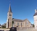
Saint-Ernier Church

La Servière mansion


Personalities
- Louis Terrenoire (1908–1992), Minister of Information (1960–1961), Mayor of Ceaucé (1959–1977)
Community partnerships
A partnership has existed with the British community of North Petherton in Somerset (England) since 1994.