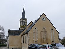
Valframbert
| Valframbert | ||
|---|---|---|
|
|
||
| region | Normandy | |
| Department | Orne | |
| Arrondissement | Alencon | |
| Canton | Damigny | |
| Community association | Alencon | |
| Coordinates | 48 ° 28 ' N , 0 ° 6' E | |
| height | 133-179 m | |
| surface | 13.95 km 2 | |
| Residents | 1,779 (January 1, 2017) | |
| Population density | 128 inhabitants / km 2 | |
| Post Code | 61250 | |
| INSEE code | 61497 | |
| Website | http://www.valframbert.fr | |
Valframbert is a French commune with 1,779 inhabitants (as of January 1 2017) in the department of Orne in the region of Normandy . Condé-sur-Sarthe belongs to the Arrondissement Alençon and the canton Damigny (until 2015: canton Alençon-3 ). The municipality is part of the communauté urbaine d'Alençon . The inhabitants are called Valframbertois .
geography
Valframbert is a banlieue in the north of Alençon . Valframbert is surrounded by the neighboring communities Radon and Forges in the north, Semallé in the east, Chenay in the southeast, Cerisé in the south, Alençon in the south and southwest and Colombiers in the west.
The A28 autoroute and the national route 12 run through the municipality .
Population development
| year | 1962 | 1968 | 1975 | 1982 | 1990 | 1999 | 2006 | 2013 |
|---|---|---|---|---|---|---|---|---|
| population | 557 | 530 | 717 | 903 | 1,398 | 1,501 | 1,550 | 1,543 |
| Source: Cassini and INSEE | ||||||||
Attractions
- Saint-Sulpice church
- Aché Castle
- Sarceaux Castle
- Requêtes Castle
Web links
Commons : Valframbert - collection of images, videos and audio files

