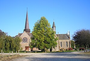
Passais Villages
| Passais Villages | ||
|---|---|---|
|
|
||
| region | Normandy | |
| Department | Orne | |
| Arrondissement | Alencon | |
| Canton | Bagnoles-de-l'Orne | |
| Community association | Andaine Passais | |
| Coordinates | 48 ° 31 ′ N , 0 ° 45 ′ W | |
| height | 130-217 m | |
| surface | 42.36 km 2 | |
| Residents | 1,191 (January 1, 2017) | |
| Population density | 28 inhabitants / km 2 | |
| Post Code | 61350 | |
| INSEE code | 61324 | |
| Website | Passais Villages | |
 Passais - chapels |
||
Passais Villages is a newly established in 2016 and of three districts and several villages (hamlets) and individual farms (fermes) existing large village ( commune nouvelle ) with 1,191 inhabitants (as of January 1 2017) in northern France Orne in the region of Normandy . Passais is the center of the large community . All merged former municipalities have the status of Commune déléguée .
location
The parish is part of the Normandy-Maine Regional Nature Park . The three districts of the municipality of Passais Villages are located in a former forest area, which has given way to a hedge landscape ( bocage ) centuries ago , about 75 km (driving distance) west of Alençon at heights of around 120 to 180 m . The climate is influenced to a large extent by the sea and is therefore almost frost-free; Rain (approx. 755 mm / year) falls throughout the year.
Population distribution and extrapolation
| District | former INSEE code |
Area (km²) |
Altitude (m) (on average) |
Population (Census) | ||||||||||
|---|---|---|---|---|---|---|---|---|---|---|---|---|---|---|
| 1851 | 1901 | 1954 | 1962 | 1968 | 1975 | 1982 | 1990 | 1999 | 2006 1 | 2016 2 | ||||
| L'Épinay-le-Comte | 61155 | 9.55 | 157-217 (180) | 920 | 611 | 494 | 405 | 381 | 306 | 262 | 239 | 188 | 184 | 187 |
| Passais | 61324 | 16.68 | 143-207 (160) | 1.991 | 1,601 | 1,214 | 1.102 | 1,031 | 1,016 | 1,020 | 915 | 889 | 787 | 769 |
| Saint-Siméon | 61455 | 16.13 | 130-212 (170) | 1,518 | 1,023 | 689 | 604 | 512 | 400 | 340 | 281 | 261 | 268 | 251 |
| Passais Villages | 61324 | 42.36 | 4,429 | 3,235 | 2,397 | 2.111 | 1.924 | 1,722 | 1,622 | 1,435 | 1,338 | 1,239 | 1,207 | |
The main reason for the emergence of new large municipalities in the various regions of France is the continuous and in many cases still persistent population decline in the rural municipalities since the middle of the 19th or the beginning of the 20th century; this is mainly due to the closure of small farms as well as the mechanization of agriculture and the associated loss of jobs.
economy
The villages of the municipality have always been oriented towards agriculture, with pasture farming playing an important role. In ancient times, the livestock trade and the manufacture and sale of cheese and charcoal were often the only sources of income for people. Since the 1960s, tourism has been playing an increasingly important role in the form of renting holiday homes ( gîtes ) .
history
For centuries the area had been largely isolated from all historical conflicts and events; only from the time of the Hundred Years War (1337-1453) are attacks known.
Attractions
Web links
Individual evidence
- ↑ Passais Villages - card with heights .
- ↑ Passais Villages - Climate table
- ↑ Data from the Communes - population census (Recensement de la population) 2006
- ↑ File of the Orne Department - Census (Recensement de la population) 2016
- ↑ Des villages de Cassini aux communes d'aujourd'hui - Index par département
