Guernsey, Wyoming
| guernsey | |
|---|---|
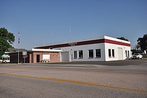
 City Hall of Guernsey |
|
| Location in Wyoming | |
| Basic data | |
| State : | United States |
| State : | Wyoming |
| County : | Platte County |
| Coordinates : | 42 ° 16 ′ N , 104 ° 45 ′ W |
| Time zone : | Mountain ( UTC − 7 / −6 ) |
| Residents : | 1,147 (as of 2010) |
| Population density : | 426.4 inhabitants per km 2 |
| Area : | 2.69 km 2 (approx. 1 mi 2 ) |
| Height : | 1327 m |
| Postal code : | 82214 |
| Area code : | +1 307 |
| FIPS : | 56-34320 |
| GNIS ID : | 1589181 |
| Website : | www.townofguernseywy.us |
Guernsey is a town in Platte County in the US state of Wyoming .
location
Guernsey is located in the east of Platte County about 30 kilometers northeast of County Seat Wheatland on the North Platte River , which is dammed about 2 km north of the city to form the Guernsey Dam , at an altitude of about 1327 m. US Highway 26 , which crosses the North Platte River here , runs through the village .
The city has an area of 2.69 km², of which 2.65 km² is land and 0.04 km² is water.
Demographics
According to the United States Census 2010 , Guernsey had 1,147 inhabitants, 552 men and 595 women. 281 residents were under 18 years old, 209 over 65.
Web links
Commons : Guernsey, Wyoming - collection of images, videos, and audio files
- Official website of Guernsey
Individual evidence
- ↑ Guernsey. In: Geographic Names Information System. Retrieved January 15, 2019 (American English).
- ↑ US Gazetteer files 2010 . United States Census Bureau . Archived from the original on January 24, 2012. Retrieved January 15, 2019.
- ^ Guernsey town, Wyoming. In: American FactFinder. US Census Bureau, accessed January 15, 2019 .
