
Livré-la-Touche
| Livré-la-Touche | ||
|---|---|---|
|
||
| region | Pays de la Loire | |
| Department | Mayenne | |
| Arrondissement | Château-Gontier | |
| Canton | Cossé-le-Vivien | |
| Community association | Pays de Craon | |
| Coordinates | 47 ° 53 ′ N , 0 ° 59 ′ W | |
| height | 39-90 m | |
| surface | 30.08 km 2 | |
| Residents | 745 (January 1, 2017) | |
| Population density | 25 inhabitants / km 2 | |
| Post Code | 53400 | |
| INSEE code | 53135 | |
| Website | http://www.mairie.livre.la.touche.mairie53.fr/ | |

Livré-la-Touche (until 2008 only livré ) is a French municipality with 745 inhabitants (as of January 1 2017) in the department of Mayenne in the region Pays de la Loire ; it is part of the arrondissement of Château-Gontier and the canton of Cossé-le-Vivien (until 2015: canton of Craon ). The inhabitants are called Livréens .
geography
Livré-la-Touche is about thirty kilometers southwest of Laval on the Oudon . Livré-la-Touche is surrounded by the neighboring communities of Méral in the north and north-west, Cossé-le-Vivien in the north and north-east, Athée in the east, Craon in the south-east, Niafles in the south, La Selle-Craonnaise in the south-west and Ballots in the west.
Population development
| year | 1962 | 1968 | 1975 | 1982 | 1990 | 1999 | 2006 | 2013 |
|---|---|---|---|---|---|---|---|---|
| Residents | 892 | 789 | 798 | 768 | 840 | 787 | 790 | 750 |
| Source: Cassini and INSEE | ||||||||
Attractions
- Notre-Dame-de-l'Assomption church from the 15th / 16th centuries Century, Monument historique
- Saint-Denis chapel in Le Blouchet from the 20th century
- Manor of L'Épronnière

Notre-Dame-de-l'Assomption church
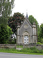
Saint-Denis chapel

Manor of L'Épronnière


literature
- Le Patrimoine des Communes de la Mayenne. Flohic Editions, Volume 1, Paris 2002, ISBN 2-84234-135-X , pp. 314-317.