
Chémeré-le-Roi
| Chémeré-le-Roi | ||
|---|---|---|
|
||
| region | Pays de la Loire | |
| Department | Mayenne | |
| Arrondissement | Château-Gontier | |
| Canton | Meslay-du-Maine | |
| Community association | Pays de Meslay-Grez | |
| Coordinates | 47 ° 59 ′ N , 0 ° 26 ′ W | |
| height | 47-111 m | |
| surface | 15.18 km 2 | |
| Residents | 402 (January 1, 2017) | |
| Population density | 26 inhabitants / km 2 | |
| Post Code | 53340 | |
| INSEE code | 53067 | |
| Website | http://www.chemereleroi.mairie53.fr/ | |
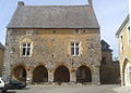
_Mairie.JPG) Town hall (Mairie) of Chémeré-le-Roi |
||

Chémeré-le-Roi is a French municipality with 402 inhabitants (as of January 1 2017) in Mayenne in the region Pays de la Loire in France . Residents of the municipality are called Chémeréens . The municipality belongs to the arrondissement of Château-Gontier (until 2017: arrondissement Laval ) and the canton of Meslay-du-Maine .
geography
Chémeré-le-Roi is located about 30 kilometers east-southeast of Laval . Chémeré-le-Roi is surrounded by the neighboring communities of La Bazouge-de-Chemeré in the north and north-west, Saulges in the north and east, Val-du-Maine in the south and south-east, Préaux in the south and La Cropte in the west and south-west.
Population development
| year | 1962 | 1968 | 1975 | 1982 | 1990 | 1999 | 2006 | 2013 |
| Residents | 581 | 520 | 443 | 417 | 383 | 403 | 460 | 434 |
| Source: Cassini and INSEE | ||||||||
Attractions
- Notre-Dame-de-l'Assomption church
- House with arches ( Maison du Porche ), Monument historique
- Thévalles castle and mill

Notre-Dame-de-l'Assomption church
Maison du Porche
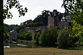
Thévalles castle and mill
_%C3%89glise_Notre-Dame_de_l%27Assomption_02.JPG)

.JPG)
Personalities
- Geneviève Duboscq (1933–2018), writer
Trivia
The Fraternité Saint-Vincent-Ferrier (so-called Old Dominicans ) was founded here in 1988.
literature
- Le Patrimoine des Communes de la Mayenne. Flohic Editions, Volume 2, Paris 2002, ISBN 2-84234-135-X , pp. 755-757.
Web links