
La Boissière (Mayenne)
| La Boissière | ||
|---|---|---|
|
||
| region | Pays de la Loire | |
| Department | Mayenne | |
| Arrondissement | Château-Gontier | |
| Canton | Cossé-le-Vivien | |
| Community association | Pays de Craon | |
| Coordinates | 47 ° 47 ′ N , 0 ° 59 ′ W | |
| height | 34-98 m | |
| surface | 6.32 km 2 | |
| Residents | 117 (January 1, 2017) | |
| Population density | 19 inhabitants / km 2 | |
| Post Code | 53800 | |
| INSEE code | 53033 | |

La Boissiere is a French municipality with 117 inhabitants (as of January 1 2017) in the department of Mayenne in the region Pays de la Loire ; it belongs to the arrondissement of Château-Gontier and is part of the canton of Cossé-le-Vivien (until 2015: canton of Craon ). The inhabitants are called Buxériens .
geography
La Boissière is located about 39 kilometers south-southwest of Laval . La Boissière is surrounded by the neighboring communities Bouchamps-lès-Craon in the north and northwest, Segré-en-Anjou Bleu in the east and southeast, Bouillé-Ménard in the south, Ombrée d'Anjou in the southwest and Renazé in the west.
Population development
| 1962 | 1968 | 1975 | 1982 | 1990 | 1999 | 2006 | 2013 |
|---|---|---|---|---|---|---|---|
| 190 | 175 | 158 | 131 | 152 | 111 | 120 | 127 |
| Source: Cassini and INSEE | |||||||
Attractions
- Saint-Serge church
- Saint-Christophe Chapel
- La Haute Bergerie mansion
- La Boissière Castle, a historic monument since 1987
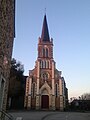
Saint-Serge church
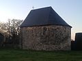
Saint-Christophe Chapel
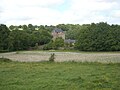
La Boissière Castle


literature
- Le Patrimoine des Communes de la Mayenne. Flohic Editions, Volume 1, Paris 2002, ISBN 2-84234-135-X , pp. 288-289.
Web links
Commons : La Boissière - Collection of images, videos and audio files