
Les Alleuds (Maine-et-Loire)
| Les Alleuds | ||
|---|---|---|
|
||
| local community | Brissac Loire Aubance | |
| region | Pays de la Loire | |
| Department | Maine-et-Loire | |
| Arrondissement | Angers | |
| Coordinates | 47 ° 19 ′ N , 0 ° 24 ′ W | |
| Post Code | 49320 | |
| Former INSEE code | 49001 | |
| Incorporation | 15th December 2016 | |
| status | Commune déléguée | |
| Website | http://www.alleuds.fr/ | |
 Town hall (Mairie) of Les Alleuds |
||

Les Alleuds is a town and commune Déléguée in the French commune of Brissac Loire Aubance with 904 inhabitants (as of January 1 2017) in the department of Maine-et-Loire in the region of Pays de la Loire . The inhabitants are called Alleusiens .
The municipality of Les Alleuds was founded on December 15, 2016 with nine other municipalities, namely Brissac-Quincé , Charcé-Saint-Ellier-sur-Aubance , Chemellier , Coutures , Luigné , Saint-Rémy-la-Varenne , Saint-Saturnin-sur- Loire , Saulgé-l'Hôpital and Vauchrétien merged to form the new municipality of Brissac Loire Aubance. It belonged to the Arrondissement of Angers and the canton of Les Ponts-de-Cé (until 2015: canton Thouarcé ).
geography
Les Alleuds is located about 19 kilometers south-southeast of Angers in the Anjou wine-growing region .
The municipality of Les Alleuds was surrounded by the neighboring municipalities of Brissac-Quincé in the north and northwest, Charcé-Saint-Ellier-sur-Aubance in the north and northeast, Saulgé-l'Hôpital in the east, Luigné in the south and southeast, Chavagnes in the south and southwest and Notre-Dame-d'Allençon to the west and south-west.
Population development
| year | 1962 | 1968 | 1975 | 1982 | 1990 | 1999 | 2006 | 2013 |
| Residents | 443 | 431 | 402 | 449 | 564 | 636 | 817 | 879 |
| Source: Cassini and INSEE | ||||||||
Attractions
- Saint-Aubin church
- Saint-Aubin Priory, Monument historique
Viticulture
The place belongs to the Anjou wine region .
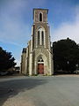
Saint-Aubin church
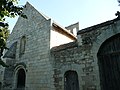
priory


literature
- Le Patrimoine des Communes de Maine-et-Loire . Flohic Editions, Volume 2, Paris 2001, ISBN 2-84234-117-1 , pp. 1255-1256.