
Dierhagen
| coat of arms | Germany map | |
|---|---|---|

|
Coordinates: 54 ° 17 ' N , 12 ° 22' E |
|
| Basic data | ||
| State : | Mecklenburg-Western Pomerania | |
| County : | Western Pomerania-Ruegen | |
| Office : | Darß / Fischland | |
| Height : | 3 m above sea level NHN | |
| Area : | 27.53 km 2 | |
| Residents: | 1532 (Dec. 31, 2019) | |
| Population density : | 56 inhabitants per km 2 | |
| Postal code : | 18347 | |
| Area code : | 038226 | |
| License plate : | VR, GMN, NVP, RDG, RÜG | |
| Community key : | 13 0 73 017 | |
| LOCODE : | DE DIA | |
| Office administration address: | Chausseestraße 68a 18375 Born a. Darß |
|
| Website : | ||
| Mayoress : | Christiane Müller ( DIE LINKE ) | |
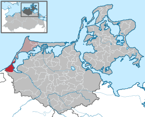
| Location of the community of Dierhagen in the district of Vorpommern-Rügen | ||
  |
||

The Ostseebad Dierhagen is a municipality northwest of Ribnitz-Damgarten in the district of Vorpommern-Rügen . The municipality is managed by the Darß / Fischland office with its seat in the municipality of Born a. Darß managed.
Historically, the place belongs to Mecklenburg .
Geography and traffic
Dierhagen lies in front of the Fischland peninsula at the beginning of the narrowing between the Baltic Sea and the Saaler Bodden . The Ostseebad Dierhagen is mostly ascribed to the Fischland, but has always belonged to the mainland. The border with Fischland, the Permin , is north of the town. The town of Ribnitz-Damgarten and the B 105 are located about twelve kilometers southeast of the municipality, and Rostock is about 35 kilometers southwest . The A 19 can be reached via the Rostock-Ost junction (approx. 32 kilometers).
In the municipality there is a larger forest area in the southwest with the foothills of the Rostock Heath . The Ribnitzer Großes Moor nature reserve is also located here and the Dierhäger Moor nature reserve a little north of it .
Community structure
The community of Dierhagen consists of six districts. These are the districts of Dierhagen Strand, Dierhagen Neuhaus and Dierhagen Ost on the Baltic Sea and the districts of Dändorf , Hof Körkwitz and Dierhagen Dorf on the Saaler Bodden .
politics
Coat of arms, flag, official seal
The municipality has no officially approved national emblem, neither a coat of arms nor a flag. The official seal is the small state seal with the coat of arms of the state of Mecklenburg. It shows a looking bull's head with torn off neck fur and crown and the inscription "GEMEINDE OSTSEEBAD DIERHAGEN".
history
Dierhagen was first mentioned in 1311. The place name could be derived from “Deerhagen” or “Thierhagen” and indicates animal husbandry and forest.
Bathing began in 1880 and tourism continued to develop. The municipal area belonged to the Duchy of Mecklenburg for centuries and in 1919 it became part of the Free State of Mecklenburg-Schwerin . The municipality was part of the Rostock district from 1933 to 1952 , then the Ribnitz-Damgarten district until 1990 and the Ribnitz-Damgarten district until 1994.
In 1998 Dierhagen received state recognition as a seaside resort .
Attractions
- Brick church from the middle of the 19th century
- Great Moor forest area
- Ports of Dierhagen and Dändorf
- Dorfstraße Dändorf - part of the historic north Mecklenburg salt road, which ran between Bad Sülze and Wismar partly on the water and partly on the land
- old captains' houses and farms
- Memorial from 1946 in the center of the village for the victims of fascism

Brick church
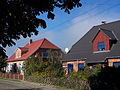
Captain's houses in Dändorf
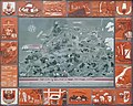
The salt road from Bad Sülze via Dändorf and Dierhagen to Wismar in the years 1243 to 1907

Port in Dierhagen


Web links
Individual evidence
- ↑ Statistisches Amt MV - population status of the districts, offices and municipalities 2019 (XLS file) (official population figures in the update of the 2011 census) ( help ).
- ↑ Main Statute, Section 1, Paragraph 2

Ahrenshagen-Daskow | Ahrenshoop | Altefähr | Altenkirchen | Altenpleen | Baabe | Bad Sülze | Barth | Mountains on Rügen | Binz | Born a. Darß | Breege | Buschvitz | Dettmannsdorf | Deyelsdorf | Dierhagen | Divitz-Spoldershagen | Dranske | Drechow | Dreschvitz | Eixen | Elmenhorst | Franzburg | Fuhlendorf | Garz / Rügen | Went | Glewitz | Glowe | Goehren | Grammendorf | Gransgebieth | Gremersdorf-Buchholz | Grim | Groß Kordshagen | Gross Mohrdorf | Gustow | Hugoldsdorf | Hiddensee Island | Jakobsdorf | Karnin | Kenz-Küstrow | Klausdorf | Kluis | Kramerhof | Lancken-Granitz | Lietzow | Lime wood | Löbnitz | Lohme | Lüdershagen | Lüssow | Marlow | Millienhagen-Oebelitz | Mönchgut | Neuenkirchen | Niepars | Pantelitz | Papenhagen | Parchtitz | Patzig | Poseritz | Preetz | Prerow | Prohn | Pruchten | Putbus | Putgarten | Ralswiek | Rambin | Rappin | Ribnitz-Damgarten | Richtenberg | Hall | Sagard | Velvet | Sassnitz | Schaprode | Schlemmin | Sehlen | Sellin | Semlow | Splietsdorf | Steinhagen | Stralsund | Süderholz | Sundhagen | Trent | Tribsees | Trinwillershagen | Ummanz | Velgast | Weitenhagen | Wendisch Baggendorf | Wendorf | Wieck a. Darß | Wiek | Wittenhagen | Wustrow | Zarrendorf | Zingst | Zirkow