
Neuenkirchen (Ruegen)
| coat of arms | Germany map | |
|---|---|---|

|
Coordinates: 54 ° 33 ' N , 13 ° 20' E |
|
| Basic data | ||
| State : | Mecklenburg-Western Pomerania | |
| County : | Western Pomerania-Ruegen | |
| Office : | West Ruegen | |
| Height : | 3 m above sea level NHN | |
| Area : | 22.93 km 2 | |
| Residents: | 278 (Dec. 31, 2019) | |
| Population density : | 12 inhabitants per km 2 | |
| Postal code : | 18569 | |
| Area code : | 038309 | |
| License plate : | VR, GMN, NVP, RDG, RÜG | |
| Community key : | 13 0 73 059 | |
| Community structure: | 13 districts | |
| Office administration address: | Dorfplatz 2 18573 Samtens |
|
| Website : | ||
| Mayor : | Sybille Görs | |
| Location of the community of Neuenkirchen in the district of Vorpommern-Rügen | ||
  |
||

Neuenkirchen is a municipality in the district of Vorpommern-Rügen on the island of Rügen in Mecklenburg-Western Pomerania (Germany). The municipality is administered by the West-Rügen Office with its seat in the municipality of Samtens .
geography
Neuenkirchen is about 20 kilometers northwest of Bergen on Rügen. The community is located on the Liddow and Lebbin peninsulas , between Lebbiner Bodden , Tetzitzer See and the Great Jasmunder Bodden . The island of Beuchel belongs to the municipality .
Community structure
|
|
history
Neuenkirchen was first mentioned in 1318 as Nygenkerke .
The place was part of the Principality of Rügen until 1326 and then the Duchy of Pomerania . With the Peace of Westphalia of 1648, Rügen and thus also the area of Neuenkirchen became part of Swedish Pomerania . In 1815 Neuenkirchen came to the Prussian province of Pomerania as part of New Western Pomerania .
Since 1818 Neuenkirchen belonged to the district or district of Rügen . Only from 1952 to 1955 it was part of the Bergen district. The community then belonged to the Rügen district in the Rostock district until 1990 and became part of the state of Mecklenburg-Western Pomerania in the same year. The district of Rügen, which has been called this again since 1990, was merged in 2011 in the district of Vorpommern-Rügen.

Grubnow: Here is the Hoch Hilgor , a mountain with a beautiful all-round view. There is the following story about the mountain:
High Hilgor: hil = hillig (German.), Holy; gor = mountain (Slav.) The Teutons created orientation aids that were made visible by fire flames (holy fire) and through which a formal system of lines for signaling and communication was created. This creates a link between ramparts and refuges with Germanic sanctuaries. These lines are oriented due east and north. Both directions played a major role in the religious cult of the Teutons. Such a sacred location should also be the Hoch Hilgor.
At 43.8 m the highest point in a chain of hills; wooded. In 1992/93 a 15.5 m high wooden tower was built here to allow an undisturbed view of the whole island. The excellent view was already described in Grümbke's travel descriptions in 1805.
Laase: In the 15th century the place was owned by the von Normann family and in the last third of the 17th century by the von Bohlen family . Colonel Günther Bronsart von Schellendorff became the landowner around 1900 and Julius Stuth in the 1920s until 1945.
Lebbin: The estate was first mentioned in a document in 1314. It was owned by the von Paselich , von Normann (14th century – 1802), von Colmar, Stahnke (from 1818) and Kroos (1905–1945) families . The two-story manor house with a baroque gable and a tower was demolished around 1980. A small port was built around 1822. After 2005 a guest house was built at the small harbor.
Tribbevitz was mentioned in a document in 1315 as an estate. Landowners were the von Normann family , then von Hagemeister, for over 500 years until the middle of the 19th century ; thereafter ownership changed frequently. The neo-Gothic manor house from the 19th century has been a country hotel since 2002.
religion
22% of the population are Protestant, 4% Catholic.
The Lutheran Maria Magdalena Church is part of the Neuenkirchen- Rappin parish, for which the Schaprode parish in the Stralsund priory of the Pomeranian Evangelical Church District of the Evangelical Lutheran Church in Northern Germany is responsible.
The local Catholics are assigned to the parish of St. Bernhard , based in Stralsund, Archdiocese of Berlin . The nearest branch church is the St. Bonifatius Church in Bergen on Rügen , 20 km away ; Catholic services are also celebrated in the Evangelical St. Jacob Church in Gingst , 11 km away .
Coat of arms, flag, official seal
The municipality has no officially approved national emblem, neither a coat of arms nor a flag . The official seal is the small state seal with the coat of arms of the region of Western Pomerania . It shows an upright griffin with a raised tail and the inscription "GEMEINDE NEUENKIRCHEN".
Attractions

- Brick church Maria Magdalena built between 1380 and 1450 with the oldest church bell in Rügen
- Trakehner Stud Gut Tribbevitz
- neo-Gothic mansion Gut Tribbevitz
- Historic manor Gut Grubnow
- Viewpoint Hoch Hilgor with Grümbke tower
- Neuendorfer Wiek nature reserve with Beuchel Island (bird island with sea birds and eagles)
- Nature reserve Tetzitzer See with the Liddow peninsula and Banzelvitzer mountains ( crane and geese resting place )
- Rodeliner Berg vantage point on Lake Tetzitzer with a view of the Great Jasmunder Bodden and valuable dry grass fauna
- Lookout point at Moritzhagen (bird resting place)
- Laas Mountains viewpoint
- Kulturgut Liddow as an exhibition and project workshop
- Vieregge harbor village
- Former military base of the NVA near Moritzhagen
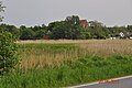
Village and church on the mountain in Neuenkirchen

Lookout tower Hoch Hilgor Grubnow
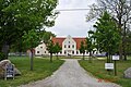
Trakehner Gut Tribbevitz
NVA object Moritzhagen - background from the north

Moritzhagen bunkers - mostly ruins


Transport links
A road about nine kilometers long leads to Neuenkirchen, which branches off from Landesstraße 30 between Gingst and Trent in the Silenz district of Kluis . The distance to the city of Bergen on Rügen is twenty kilometers. The nearest train station is also in Bergen.
Individual evidence
- ↑ Statistisches Amt MV - population status of the districts, offices and municipalities 2019 (XLS file) (official population figures in the update of the 2011 census) ( help ).
- ↑ 2011 census
- ↑ Main Statute, Section 1, Paragraph 1 (PDF).
Web links

Ahrenshagen-Daskow | Ahrenshoop | Altefähr | Altenkirchen | Altenpleen | Baabe | Bad Sülze | Barth | Mountains on Rügen | Binz | Born a. Darß | Breege | Buschvitz | Dettmannsdorf | Deyelsdorf | Dierhagen | Divitz-Spoldershagen | Dranske | Drechow | Dreschvitz | Eixen | Elmenhorst | Franzburg | Fuhlendorf | Garz / Rügen | Went | Glewitz | Glowe | Goehren | Grammendorf | Gransgebieth | Gremersdorf-Buchholz | Grim | Groß Kordshagen | Gross Mohrdorf | Gustow | Hugoldsdorf | Hiddensee Island | Jakobsdorf | Karnin | Kenz-Küstrow | Klausdorf | Kluis | Kramerhof | Lancken-Granitz | Lietzow | Lime wood | Löbnitz | Lohme | Lüdershagen | Lüssow | Marlow | Millienhagen-Oebelitz | Mönchgut | Neuenkirchen | Niepars | Pantelitz | Papenhagen | Parchtitz | Patzig | Poseritz | Preetz | Prerow | Prohn | Pruchten | Putbus | Putgarten | Ralswiek | Rambin | Rappin | Ribnitz-Damgarten | Richtenberg | Hall | Sagard | Velvet | Sassnitz | Schaprode | Schlemmin | Sehlen | Sellin | Semlow | Splietsdorf | Steinhagen | Stralsund | Süderholz | Sundhagen | Trent | Tribsees | Trinwillershagen | Ummanz | Velgast | Weitenhagen | Wendisch Baggendorf | Wendorf | Wieck a. Darß | Wiek | Wittenhagen | Wustrow | Zarrendorf | Zingst | Zirkow