
Velvet
| coat of arms | Germany map | |
|---|---|---|

|
Coordinates: 54 ° 21 ' N , 13 ° 18' E |
|
| Basic data | ||
| State : | Mecklenburg-Western Pomerania | |
| County : | Western Pomerania-Ruegen | |
| Office : | West Ruegen | |
| Height : | 9 m above sea level NHN | |
| Area : | 32.48 km 2 | |
| Residents: | 1938 (Dec. 31, 2019) | |
| Population density : | 60 inhabitants per km 2 | |
| Postal code : | 18573 | |
| Area code : | 038306 | |
| License plate : | VR, GMN, NVP, RDG, RÜG | |
| Community key : | 13 0 73 079 | |
| LOCODE : | DE SMT | |
| Address of the municipal administration: |
Dorfplatz 2 18573 Samtens |
|
| Mayoress : | Karin Wodrich | |
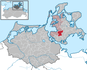
| Location of the municipality of Samtens in the district of Vorpommern-Rügen | ||
  |
||

Samtens is a municipality in the district of Vorpommern-Rügen on the island of Rügen in Mecklenburg-Western Pomerania (Germany). The municipality is the administrative seat of the West-Rügen Office , to which another ten municipalities belong. The place forms a basic center for its surroundings .
Geography and traffic
Samtens is located around 20 kilometers northeast of Stralsund and around ten kilometers southwest of Bergen. The federal highway 96 and the railway line Stralsund-Sassnitz run through the place. The community is one of the few inland communities on Rügen.
Districts
|
|
|
history

- History of the municipality
The area was part of the Principality of Rügen until 1325 and then the Duchy of Pomerania . With the Peace of Westphalia of 1648, Rügen and thus also the place Samtens came under Swedish rule, after the place previously belonged to the Duchy of Pomerania . In 1815 the municipality and Western Pomerania came to the Prussian province of Pomerania . Since 1818 Samtens belonged to the district of Rügen . It was only part of the Putbus district from 1952 to 1955 . The community then belonged to the Rügen district in the Rostock district until 1990 and became part of the state of Mecklenburg-Western Pomerania in the same year. The district of Rügen, which has been called this again since 1990, was merged in 2011 in the district of Vorpommern-Rügen.
- Velvet
Samtens was first mentioned in 1318 as "Samtensze". The place name is of Slavic origin and means something like lonely .
- Pluggentin
The Plüggentin estate had been owned by the von Grundis family since the 13th century. At the beginning of the 16th century it came to the Eldena monastery near Greifswald, but the monastery sold the property to the von der Osten family as early as 1520 . The von Vieregge family bought it in 1717, but the Northern War got them into trouble and the estate was sold. But now the estate became a rolling stock, that is, it had constantly changing owners. Then it became more stable, with von Wolffradt from 1730 to 1766, then von der Lancken until 1901, followed by von Langen and around 1914 the Sprickerhof family until 1945.
The manor house - nine axles with a richly structured facade, was built by Lancken in 1888, but the last of the latter fell on a riding horse in 1901 and broke his neck.
politics
coat of arms
The coat of arms was approved on September 19, 2000 by the Ministry of the Interior and registered under the number 225 of the coat of arms of Mecklenburg-Western Pomerania.
Blazon : “Square of green and silver; Crossed diagonally a fallen silver hoe with a leaf pointing outwards and a fallen green key with a beard pointing outwards, accompanied: above by a bell, below by a cogwheel, both in confused colors. "
The coat of arms was designed by Gerhard Koggelmann from Sagard .
Education and sport
- Since the 2008/09 school year there has only been one primary school in Samtens. Here children from Samtens, Dreschvitz, Rambin and Altefähr are taught from first to fourth grade.
- SV Samtens has soccer and table tennis teams in its club.
- Since 2003 there is a local branch of the German Lifesaving Society (DLRG)
Attractions

→ See: List of architectural monuments in Samtens
- Samtens Church - brick church from the 14th century
- Plüggentin manor
swell
- ↑ Statistisches Amt MV - population status of the districts, offices and municipalities 2019 (XLS file) (official population figures in the update of the 2011 census) ( help ).
- ↑ Regional Spatial Development Program Vorpommern (RREP) 2010 ( Memento of the original from September 24, 2015 in the Internet Archive ) Info: The archive link was inserted automatically and has not yet been checked. Please check the original and archive link according to the instructions and then remove this notice. - Central local structure with regional, medium and basic centers, accessed on July 12, 2015
- ^ Hubertus Neuschäffer: Western Pomerania's castles and mansions . Husum Druck- und Verlagsgesellschaft 1993, p. 152, ISBN 3-88042-636-8
- ↑ Main statute, § 1, Paragraph 2 ( Memento of February 1, 2014 in the Internet Archive ) (PDF; 1.0 MB)
Web links

Ahrenshagen-Daskow | Ahrenshoop | Altefähr | Altenkirchen | Altenpleen | Baabe | Bad Sülze | Barth | Mountains on Rügen | Binz | Born a. Darß | Breege | Buschvitz | Dettmannsdorf | Deyelsdorf | Dierhagen | Divitz-Spoldershagen | Dranske | Drechow | Dreschvitz | Eixen | Elmenhorst | Franzburg | Fuhlendorf | Garz / Rügen | Went | Glewitz | Glowe | Goehren | Grammendorf | Gransgebieth | Gremersdorf-Buchholz | Grim | Groß Kordshagen | Gross Mohrdorf | Gustow | Hugoldsdorf | Hiddensee Island | Jakobsdorf | Karnin | Kenz-Küstrow | Klausdorf | Kluis | Kramerhof | Lancken-Granitz | Lietzow | Lime wood | Löbnitz | Lohme | Lüdershagen | Lüssow | Marlow | Millienhagen-Oebelitz | Mönchgut | Neuenkirchen | Niepars | Pantelitz | Papenhagen | Parchtitz | Patzig | Poseritz | Preetz | Prerow | Prohn | Pruchten | Putbus | Putgarten | Ralswiek | Rambin | Rappin | Ribnitz-Damgarten | Richtenberg | Hall | Sagard | Velvet | Sassnitz | Schaprode | Schlemmin | Sehlen | Sellin | Semlow | Splietsdorf | Steinhagen | Stralsund | Süderholz | Sundhagen | Trent | Tribsees | Trinwillershagen | Ummanz | Velgast | Weitenhagen | Wendisch Baggendorf | Wendorf | Wieck a. Darß | Wiek | Wittenhagen | Wustrow | Zarrendorf | Zingst | Zirkow