Altefähr
| coat of arms | Germany map | |
|---|---|---|

|
Coordinates: 54 ° 20 ' N , 13 ° 8' E |
|
| Basic data | ||
| State : | Mecklenburg-Western Pomerania | |
| County : | Western Pomerania-Ruegen | |
| Office : | West Ruegen | |
| Height : | 13 m above sea level NHN | |
| Area : | 20.59 km 2 | |
| Residents: | 1283 (Dec. 31, 2019) | |
| Population density : | 62 inhabitants per km 2 | |
| Postal code : | 18573 | |
| Area code : | 038306 | |
| License plate : | VR, GMN, NVP, RDG, RÜG | |
| Community key : | 13 0 73 003 | |
| Office administration address: | Dorfplatz 2 18573 Samtens |
|
| Website : | ||
| Mayor : | Frank Lutz Jätschmann ( SPD ) | |
| Location of the community Altefähr in the district of Vorpommern-Rügen | ||
The seaside resort Altefähr is a municipality in the district of Vorpommern-Rügen on the island of Rügen in Mecklenburg-Western Pomerania (Germany). The municipality is administered by the West-Rügen Office with its seat in the municipality of Samtens . Altefähr has been recognized as a state seaside resort since August 15, 2016.
Geography and traffic
The municipality of Seebad Altefähr is located on the Stralsund opposite bank of the Strelasund , which separates the island of Rügen from the West Pomeranian mainland.
The federal highway 96 and the railway line Stralsund – Sassnitz run through the community.
Districts
The districts of Altefähr, Barnkevitz, Grahlerfähre, Grahlhof, Groß Bandelvitz, Gustrowerhöfen, Jarkvitz, Klein Bandelvitz, Kransdorf, Papenhagen, Poppelvitz, Scharpitz and Schlavitz belong to the municipality of Seebad Altefähr.
history

Altefähr has probably served as a ferry port since 1200. The first indirect mention of the place can be found in the second city charter for Stralsund from 1240 - the original in the Stralsund city archive. The area of the old ferry village on the mainland was also transferred to the new city, which requires the existence of a ferry dock on the island side. The ferry connection between Stralsund and Altefähr was the most important for all of Rügen. In the log of the Swedish surveyor from 1695 12 large and 8 small boats are listed and it is mentioned that it is the only ferry with which horses and other large cattle can be transported. In 1854 Altefähr bought the ferry from the city of Stralsund. At the end of the 19th century the ferry between Rügen and Stralsund reached its maximum capacity; mainly agricultural products were transported.
The place took another upswing with the start of rail ferry traffic. From 1909 the railway ferry was part of the express train connection between Berlin and Stockholm , which included the ferry connection of the royal line ( Sassnitz - Trelleborg ). In 1936, after the completion of the Rügen dam , rail and ferry traffic was stopped. In 2007 the new high bridge of the Strelasund crossing was inaugurated.
The place was part of the Principality of Rügen until 1325 and then of the Duchy of Pomerania . Extensive fortifications were built here before and after the Thirty Years' War to protect Stralsund and the western entrance to Strelasund. With the Peace of Westphalia in 1648, Rügen came under Swedish rule. In 1815 the municipality with the island of Rügen and Western Pomerania came to the Prussian province of Pomerania .
Since 1818 Altefähr has belonged to the district or district of Rügen , from 1952 to 1955 to the district of Putbus , then to 1990 to the district of Rügen in the Rostock district , since 1990 to the district of Rügen and since 2011 to the district of Vorpommern-Rügen.
After 1990 a beach promenade was built in Altefähr. The tourist offer includes guesthouses, a hotel, a campsite and a water hiking base with boat moorings. Since 2000, the town center has been redeveloped with funds from urban development funding .
politics
coat of arms
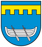
The coat of arms was designed by the heraldist Bernhard Nowak from the Heraldic Society "Black Lion" Leipzig in 1988, approved on May 27, 2003 by the Ministry of the Interior and registered under No. 278 in the coat of arms of the country.
Blazon : "In blue a raised, five-pointed gold tournament collar, underneath a silver boat with two sloping oars."
In the national emblem, the rowboat is intended to create a visual reference to the name of the municipality and to symbolize the ferry service that has been operated with such boats for centuries. The tournament collar symbolizes the Rügen dam. The construction work for the 2540 meter long roadway for railways and cars began in 1933. It was not until the opening of the Rügen dam in October 1936 for rail traffic and Pentecost 1937 for car traffic that the ferry service increasingly lost its importance. Altefähr became a seaside resort and local recreation area for the Hanseatic city of Stralsund. The tinging of the coat of arms in blue refers to the Strelasund.
flag
The flag of the municipality of Altefähr is striped in white, blue, white, blue and white across the longitudinal axis of the flag cloth. The white stripes on the leech and on the flight hem each take up a tenth, the blue stripes a fifth, and the white central stripe four tenths of the length of the flag cloth. In the middle of the white central strip is the municipal coat of arms, which takes up half the height of the flag. The relation of the height of the flag cloth to the length is like 3: 5.
Personalities
- Walter Köster (1903–1991), teacher and writer
Attractions
→ See also: List of architectural monuments in Altefähr
- Gothic village church of St. Nicholas : hall church of brick, fed, rectangular, flat roofed choir from the 15th century nave with later barrel vault of 1737, West Tower of brick with half-timbered upper floor of 1692 and an octagonal spire . The altar from 1746 comes from the workshop of Michel Müller.
- Promenade
- Manor house Kransdorf: One-storey, refurbished brick building from the end of the 19th century with a two-storey central risalit , field stone base and a half-hip roof
- Poppelvitz: Small manor house with an old garden that was owned by the Stralsund Church from the 16th to the 20th century. Completely restored since 2006 and used for holiday apartments.
Web links
Individual evidence
- ↑ Statistisches Amt MV - population status of the districts, offices and municipalities 2019 (XLS file) (official population figures in the update of the 2011 census) ( help ).
- ^ Government MV: health resorts and recreational areas in Mecklenburg-Western Pomerania (status: February 2018)
- ↑ Main statute of the municipality of Altefähr. (PDF; 3.02 MB) August 1, 2005, p. § 1 para. 2 , accessed on May 12, 2015 .
- ↑ Main statute of the municipality of Altefähr. (PDF; 3.02 MB) August 1, 2005, p. § 1 para. 3 , accessed on May 12, 2015 .


