
Tribsees
| coat of arms | Germany map | |
|---|---|---|

|
Coordinates: 54 ° 6 ′ N , 12 ° 45 ′ E |
|
| Basic data | ||
| State : | Mecklenburg-Western Pomerania | |
| County : | Western Pomerania-Ruegen | |
| Office : | Recknitz-Trebeltal | |
| Height : | 4 m above sea level NHN | |
| Area : | 54.76 km 2 | |
| Residents: | 2612 (Dec. 31, 2019) | |
| Population density : | 48 inhabitants per km 2 | |
| Postal code : | 18465 | |
| Area code : | 038320 | |
| License plate : | VR, GMN, NVP, RDG, RÜG | |
| Community key : | 13 0 73 093 | |
| LOCODE : | DE ZHV | |
| City structure: | 5 districts | |
City administration address : |
Karl-Marx-Strasse 18 18465 Tribsees |
|
| Website : | ||
| Mayor : | Bernhard Zieris | |
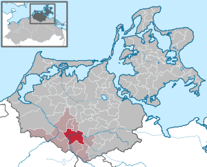
| Location of the city of Tribsees in the Vorpommern-Rügen district | ||
  |
||

Tribsees is a Western Pomerania country town and municipality in Mecklenburg-Western Pomerania in the south of the Western Pomerania-Rügen district . It is the seat of the Recknitz-Trebeltal office and forms a basic center for its surroundings .
geography
Geographical location

Tribsees is located between Rostock and Greifswald on the Trebel and not far from the Recknitz in a sparsely populated region. In the Mecklenburg-Western Pomerania border valley , the city is on the Pomeranian side of the Trebel. To the north of the city are the Grenztalmoor and the confluence of the Blinden Trebel in the Trebel.
City structure
Tribsees consists of the following districts:
- Tribsees
- Country village
- Candidate
- Siemersdorf
- Stremlow
Neighboring communities
Neighboring communities of Tribsees are: Hugoldsdorf in the north, Drechow and Gremersdorf-Buchholz in the northeast, Gransebieth in the east, Grammendorf in the southeast, Deyelsdorf in the south, Lindholz in the southwest, Bad Sülze (city) in the west and Eixen in the northwest.
history


Tribsees
A prominent island is drawn in the matriculation card from 1696. A castle complex has long been suspected at the site of the Gerberhof in the north of Tribsee. During construction work for a new Trebel Bridge in 2010, the remains of a wooden box construction were found that were interpreted as part of a Slavic castle from the Middle to Late Slavic period (800 to 1200).
To the east of the city there is also a large Slavic castle wall, the so-called "Castellanei". They are the remains of an originally multi-part castle wall, which was largely destroyed above ground and which is perhaps the main castle of the former state of Tribsees (Tribuzes). In a document from 1136 there was a sketch of this castle complex, which Hasselbach reproduced in a modernized way in 1849. Due to the few finds, the complex cannot be dated more precisely.
The name of the city is likely to be derived from the Slavic treb or trebez (Polish: "trzebiez") equal to reut, clearing .
In 995 the annalist of St. Gallen named the Tribeden as a tribal name in the area. The Tribsees landscape was first mentioned in 1136, a Tribsees castle was first mentioned in 1140. In 1241 the Tribsees bushel measure was mentioned in Lübeck . From 1245 to 1456, the Neuenkamp monastery held the patronage of the Tribsees church. In 1285, Prince Wizlaw II of Rügen confirmed the town charter of Luebeck, but Tribsees had previously appeared as a German town in a document from 1267; the council concluded a settlement with Stralsund on the recognition of mutual certificates and affirmed it with the city seal. As a result of the First War of the Rügen Succession , Tribsees came to Mecklenburg in 1328 , which only returned it to Pomerania-Wolgast in 1355 after the Second War of the Rügen Succession as heir of the Princes of Rügen, who died out in 1325.
Tribsees was an important border crossing to the west; In the castle on the eastern edge of the city, a ducal bailiff , later governor , was in office, who since the end of the 15th century also managed the neighboring bailiwick of Grimmen .
According to the cadastre of 1624, the city of Tribsees had 87 full and 71 half heirs.
During the Thirty Years War , Tribsees was fortified as a border town and later occupied by Wallenstein . After the end of the war, Tribsees belonged to the Swedish Pomerania . In 1702 the city burned down almost completely. A general collection was held in the Kingdom of Sweden to support the reconstruction ; in 1706 there were already 58 houses in the city again.
At the end of the 18th century the city had a little over 1000 inhabitants. After the Congress of Vienna in 1815, Tribsees became Prussian, like all of the former Swedish Pomerania. The connection to the railway network took place in 1895 with the inauguration of the Franzburger Südbahn to Velgast .
Like many other cities, the Great Depression drove Tribsees into insolvency in 1931. During the Second World War , shortly before the end of the war, SS units blew up the railway bridge.
During the GDR era there were u. a. in Tribsees a metalworking VEB and a pump repair company.
In 1991, Tribsees, unusual for such a small town, became a model town for urban development funding in the new federal states. The historic town center of the country town on the Trebel was renovated.
Royal Main Customs Office
Tribsees was the seat of the secondary tax office of the main customs office in Greifswald from 1821 to 1827. With the reorganization of the existing main customs offices in Greifswald, Stralsund and Wolgast, a fourth main customs office was established in Tribsees. It was the only mainland customs office and its founding is an indication of the ever increasing volume of goods traffic in the Mecklenburg territory. With the entry into force of the North German Confederation in 1867, the tasks of this main customs office became superfluous. The buildings on the market in the city of Tribsees were sold by auction in 1869 and operations ceased.
Country village
The name Landsdorf refers to belonging to the country, i.e. directly to the possession of the Pomeranian dukes - the so-called ducal table goods . In the 16th century, the von Behr family also held knighthood shares in the total hooves of the estate. The von Beringe family can be traced back to the early 18th century and acquired the last Domanialhufen in 1822. In 1834 they leased the approximately 650 hectare estate to a Mr. J. Holtz. In 1854, Mr. F. Wüstenberg entered the lease with the von Beringe. In 1862 Mr. A. Eggert became the tenant of this property. In 1879 the von Beringe family is still mentioned as the owner in the goods address book. In 1888, Mr. A. Eggert is listed as the owner of the property and he then sold it in 1905 to Mr. F. Hahn, who owned the property until it was expropriated in 1945. The neoclassical manor house from after 1862 with north / east wing from after 1905 was the Soviet headquarters after 1945 , then refugee accommodation or residential house with restaurant and consumption . It became a vacation home in 2001. The manor park is well preserved and expanded from its pre-1945 state, but the extensive manor buildings have disappeared.
Candidate
The Rekentin estate was u. a. owned by the de Rekentin families (1255–1653), von Peterswald (from 1756), von Behr- Negendanks (19th century), Westphal (from 1859), von Bassewitz (from 1881) and von Calließ (from 1890); In 1908 the estate was relocated. The classical manor house dates from the second half of the 19th century. The manor house, estate and park are still largely preserved.
Stremlow
Landowners in Stremlow were u. a. the Pomeranian dukes and - to a lesser extent - the Neuenkamp monastery and the Adam Behr family (from 1591, possibly from the 13th century). The Swedish field marshal Johan Baner took the estate from Georg von Behr in 1638 and gave it to Colonel Hans Wachtmeister . In 1815 Colonel Gustav Bernhard von Hennigs and in 1883 Georg von Bülow (1883–1945, 650 hectares) bought it for 650,000 marks. Herbert von Bülow was the owner from 1918 until 1945.
The manor house came from after 1883; Damaged by fire, it was a refugee shelter after 1945, later the administrative headquarters of the machine-tractor station (MTS), then the LPG , and there was also a consumer sales point in the house. The owner then became the Kreisbetrieb für Landtechnik (KFL), which was established in the farm buildings of the estate. In the 1970s the house was cleared and then stood empty. The KFL had the manor house demolished in 1988 due to irreparable construction defects and damage.
After 1990 the "Trebeltal Structural Funding Association" was established in the former estate area. He set up workshops for ABM projects in the buildings . A home parlor, an agricultural equipment collection, a stone oven bread bakery, a petting zoo, a biker hotel and a Slavic settlement with log houses, cattle stalls, a kiln and tar smelting were built. Park and village grounds have been restored and cared for.
The landmark of the village is an old oak tree with a stork's nest on top of the stump.
Incorporations
Landsdorf was incorporated into Tribsees on July 1, 1950, the neighboring village of Siemersdorf on June 13, 1999.
District and official affiliation
Tribsees was part of the Prussian district of Grimmen in the province of Pomerania from 1818 to 1945 , until 1932 in the administrative district of Stralsund , then in the administrative district of Stettin . From 1945 the Grimmen district belonged to the newly formed state of Mecklenburg-Western Pomerania (from 1947 Mecklenburg ). From 1952 to 1994, Tribsees one of three towns in the district of Stralsund the GDR - district Rostock (from 1990 in the state of Mecklenburg-Vorpommern). Since the district reform in 2011 , the city has belonged to the district of North Western Pomerania , since the district reform in 2011 it has been part of the district of Western Pomerania-Rügen .
Since 1992 made Tribsees together with the communities Drechow , Hugoldsdorf and Siemersdorf the Office Tribsees . On February 15, 2004, the offices of Tribsees and Bad Sülze and the communities of Deyelsdorf , Grammendorf and Gransebieth merged to form the Recknitz-Trebeltal office .
Population development
|
|
from 1990: as of December 31 of the respective year
politics

City council
The Tribsees city council consists of 12 members and the mayor. The election for the city council on May 26, 2019 had the following result with a turnout of 55.8 percent:
| Party / applicant | Share of votes | Seats |
| Free voter community "We for Tribsees" | 47.9% | 6th |
| CDU | 40.7% | 5 |
| Individual applicant Jörg Kühnhold | 8.0% | 1 |
mayor
- until 2009: Lothar Schimmelpfennig
- 2009–2019: Thomas Molkentin (CDU)
- since 2019: Bernhard Zieris (We for Tribsees)
Zieris was elected in the mayoral election on May 26, 2019 with 54.7 percent of the valid votes.
coat of arms
.png)
The coat of arms was confirmed on June 20, 2000 by the Ministry of the Interior and registered under the number 210 of the coat of arms of Mecklenburg-Western Pomerania.
Blazon : "keeping in silver a red castle battlement wall and three open gates, two side towers with pointed roofs and knobs and a crenellated central tower from which a gold reinforced Red Cross grows up in the clutches of a golden Banners with a dreilätzigen Lehnfahne that the golden Field shows a striding, red-tongued, blue lion. "
The coat of arms was redrawn in 1999 by the Schwerin heraldist Heinz Kippnick .
flag
The flag is evenly striped lengthways with red and silver (white), in the middle lies the city coat of arms on two thirds of each of the red and silver (white) stripes. The length of the flag cloth is related to the height as 5: 3.
Attractions
Buildings

- Old town
- St. Thomas Church , brick Gothic, 13./15. Century, named after the Archbishop of Canterbury Thomas Becket
- Mill gate , brick Gothic, 13th century
- Stone gate , brick Gothic, 13th century, with a local museum
- Birth house of the painter Louis Douzette
- Birthplace of the local poet and honorary citizen Heinrich Bandlow
- Western Pomeranian Potato Museum Tribsees, opened in 2000
- Memorial stele for the victims of the wars and in memory of the resistance fighters against fascism in the park on Clara-Zetkin-Strasse, erected in the 1970s
- Landsdorf manor, neoclassical building from after 1862 with north / east wing from after 1905
- Grenztalmoorbrücke on the A 20 motorway

Thomas Church

Mill gate

Stone gate
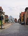
Main street with stone gate


Green areas and local recreation
- Stremlow Manor Park
- Stremlow Tower Hill
- Slavic settlement with log houses, stables, fences, kilns, tar smelting
- Rekentin Manor Park
- Border valley moor west of Tribsees with numerous peat cuttings from the 18th to 20th centuries
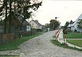
Stremlow village street with a stork tree

Slavic settlement Stremlow

Stremlow home parlor

Stremlow: Agricultural Equipment Exhibition


Economy and Infrastructure

Companies
The city is mainly characterized by agriculture. There are commercial settlements in Tribsees and a few in the districts.
traffic
Tribsees is located on the L 19 state roads between Bad Sülze and Grimmen and L 192 to Franzburg .

In the south of the city, the A 20 motorway runs from Rostock via Neubrandenburg to the Uckermark motorway triangle . Since the foundation of the autobahn failed at Tribsees , it began to sag over a large area at the end of 2017 and had to be closed in both directions. Since December 11, 2018, traffic has been routed over a temporary bridge, meaning that diversion is no longer necessary. The final restoration is planned for the end of 2023.
Tribsees has had no rail connection since the connection to Velgast was closed in 1995. The Tribsees train station was once the starting point for railway lines to Rostock , Velgast , Stralsund and Greifswald . The listed building is now used as a residential building.
Tribsees is located on the historical Via baltica branch of the Way of St. James .
There is a resting place for water hikers at the Trebel .
Personalities
Honorary citizen
- Heinrich Bandlow (1855–1933), writer
- 1996: Karl Worm (1911–1999), local history researcher and city chronicler
- 2014: Johann Joachim Spalding (1714–1804), theologian, on his 300th birthday
sons and daughters of the town
- Johann Joachim Spalding (1714–1804), theologian
- Friedrich Andreas Stroth (1750–1785), classical philologist and theologian
- Louis Douzette (1834–1924), painter
- Victor von Hennigs (1848–1930), Lieutenant General, born in Stremlow
- Waldemar von Hennigs (1849–1917), Lieutenant General, born in Stremlow
- Karl Behrens (1854–1906), engineer and entrepreneur
- Heinrich Bandlow (1855–1933), writer
- Heinrich Graf von Hardenberg (1902–1980), diplomat, born in Stremlow
- Manfred Bleskin (1949–2014), journalist and television presenter, born in Landsdorf
Personalities associated with Tribsees
- Heinrich Friedrich Haker (1823–1907), businessman, grew up in Tribsees
- Karl Worm (1911–1999), local history researcher and city chronicler
- Gerhard Dallmann (* 1926), pastor in Tribsees
literature
- Gustav Kratz : The cities of the province of Pomerania - an outline of their history, mostly according to documents . Berlin 1865, p. 524-528 ( full text ).
- Ernst Bahr, Klaus Conrad: Tribsees. In: Helge bei der Wieden , Roderich Schmidt (Hrsg.): Handbook of the historical sites of Germany . Volume 12: Mecklenburg / Pomerania (= Kröner's pocket edition . Volume 315). Kröner, Stuttgart 1996, ISBN 3-520-31501-7 , p. 305 f.
- Andreas Neumerkel: Small town on the Trebel with an eventful history. In: Pomerania. Journal of Culture and History. Issue 4/2010, ISSN 0032-4167 , pp. 6-8.
Web links
Individual evidence
- ↑ Statistisches Amt MV - population status of the districts, offices and municipalities 2019 (XLS file) (official population figures in the update of the 2011 census) ( help ).
- ↑ Regional Spatial Development Program Western Pomerania. In: rpv-vorpommern.de. Regional Planning Association Vorpommern, accessed on September 13, 2019 .
- ↑ § 1 of the main statute of the city of Tribsees
- ↑ Kunkel-1932, Corpus-1988, Hasselbach-1849 and MTB 1880
- ^ Klaus Conrad (arrangement): Pommersches Urkundenbuch . Volume 1. 2nd edition. Böhlau Verlag, Cologne / Vienna 1970, No. 27.
- ^ Klaus Conrad (arrangement): Pommersches Urkundenbuch. Volume 1. 2nd edition. Böhlau Verlag, Cologne / Vienna 1970, No. 30.
- ^ Directory of the governors from 1483 to 1634/38 at Dirk Schleinert : The estate economy in the Duchy of Pommern-Wolgast in the 16th and early 17th centuries. Cologne / Weimar / Vienna 2001, p. 286f.
- ↑ Stralsund City Archives, Rep. 13, No. 1595.
- ^ Thomas Molkentin: City history (s) Tribsees - A city becomes Prussian! Ed .: Thomas Molkentin. 1st edition 2015.
- ↑ On February 15, 1653, Christoff Rekentin sold his property Rekentin to the Swedish accountant Olaff Persohn Feldberg (Stralsund City Archives, City Documents, No. 2399).
- ^ Eckhard Oberdörfer: North Western Pomerania . Edition Temmen, Bremen 2002, pp. 145–146. ISBN 3-86108-480-5
- ↑ StBA: Changes in the municipalities in Germany, see 1999
- ↑ stadt.tribsees.kreis-grimmen.de , community encyclopedia for the Free State of Prussia. Pomeranian Province. According to the final result of the census of June 16, 1925 and other official sources based on the territory of October 1, 1932 . Prussian State Statistical Office, Berlin 1932, p. 32
- ^ Local lexicon of the GDR, 1971 edition, as of January 1, 1970
- ↑ Population development of the districts and municipalities in Mecklenburg-Western Pomerania (Statistical Report AI of the Statistical Office Mecklenburg-Western Pomerania)
- ↑ Announcement of the final election results of the Tribsees city council on May 26, 2019
- ↑ Three people from Tribsee want to become mayors. In: Ostsee-Zeitung , March 13, 2014.
- ↑ Announcement of the final result of the mayor's election on May 26, 2019
- ↑ Hole in German autobahn increased to 95 meters in length. In: derstandard.at. February 8, 2018, accessed September 13, 2019 .
- ↑ A20 hole: The temporary bridge has been released. In: ndr.de. December 12, 2018, accessed September 13, 2019 .
- ↑ Start of construction for the new A20 bridge near Tribsees. In: ndr.de. August 19, 2019, accessed September 13, 2019 .
- ↑ Via Baltica - The Baltic-Westphalian Way
- ↑ Virtual map
- ↑ Karl Worm on stadt-tribsees.de
- ↑ Spalding is to become an honorary citizen. In: Ostsee-Zeitung , September 25, 2014.

Ahrenshagen-Daskow | Ahrenshoop | Altefähr | Altenkirchen | Altenpleen | Baabe | Bad Sülze | Barth | Mountains on Rügen | Binz | Born a. Darß | Breege | Buschvitz | Dettmannsdorf | Deyelsdorf | Dierhagen | Divitz-Spoldershagen | Dranske | Drechow | Dreschvitz | Eixen | Elmenhorst | Franzburg | Fuhlendorf | Garz / Rügen | Went | Glewitz | Glowe | Goehren | Grammendorf | Gransgebieth | Gremersdorf-Buchholz | Grim | Groß Kordshagen | Gross Mohrdorf | Gustow | Hugoldsdorf | Hiddensee Island | Jakobsdorf | Karnin | Kenz-Küstrow | Klausdorf | Kluis | Kramerhof | Lancken-Granitz | Lietzow | Lime wood | Löbnitz | Lohme | Lüdershagen | Lüssow | Marlow | Millienhagen-Oebelitz | Mönchgut | Neuenkirchen | Niepars | Pantelitz | Papenhagen | Parchtitz | Patzig | Poseritz | Preetz | Prerow | Prohn | Pruchten | Putbus | Putgarten | Ralswiek | Rambin | Rappin | Ribnitz-Damgarten | Richtenberg | Hall | Sagard | Velvet | Sassnitz | Schaprode | Schlemmin | Sehlen | Sellin | Semlow | Splietsdorf | Steinhagen | Stralsund | Süderholz | Sundhagen | Trent | Tribsees | Trinwillershagen | Ummanz | Velgast | Weitenhagen | Wendisch Baggendorf | Wendorf | Wieck a. Darß | Wiek | Wittenhagen | Wustrow | Zarrendorf | Zingst | Zirkow