Recknitz
| Recknitz | ||
|
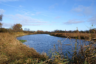
The Recknitz in Ribnitz-Damgarten |
||
| Data | ||
| Water code | DE : 9652 | |
| location | Mecklenburg-Western Pomerania | |
| River system | Recknitz | |
| River basin district | Warnow / Peene | |
| source | north of Teterow as Schaalbeke 53 ° 49 ′ 37 ″ N , 12 ° 26 ′ 53 ″ E |
|
| Source height | approx. 44 m | |
| muzzle | in the Saaler Bodden near Ribnitz-Damgarten Coordinates: 54 ° 15 ′ 7 ″ N , 12 ° 27 ′ 25 ″ E 54 ° 15 ′ 7 ″ N , 12 ° 27 ′ 25 ″ E |
|
| Mouth height | 0 m above sea level NHN | |
| Height difference | approx. 44 m | |
| Bottom slope | approx. 0.5 ‰ | |
| length | 88 km | |
| Catchment area | 669 km² | |
| Discharge at the Bad Sülze A Eo gauge : 429 km² Location: 31 km above the estuary |
NNQ (07.09.2001) MNQ 1998–2005 MQ 1998–2005 Mq 1998–2005 MHQ 1998–2005 HHQ (14.12.1998) |
619 l / s 875 l / s 2.43 m³ / s 5.7 l / (s km²) 12.8 m³ / s 20.3 m³ / s |
| Left tributaries | Schulenberger Mühlenbach, Maibach, Reppeliner Bach | |
| Right tributaries | Tribohmer Bach , Polchow, Pludderbach | |
| Small towns | Laage , Ticino , Bad Sülze , Marlow , Ribnitz-Damgarten | |
The Recknitz is a river in Mecklenburg-Western Pomerania and namesake of the Recknitz-Trebeltal office .
course

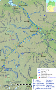
The Recknitz is 88.9 km long and drains an area of 669 km². It rises north of Teterow between Warnkenhagen and Dalkendorf as Schaalbeke and flows into the Saaler Bodden at Ribnitz-Damgarten .
The Schaalbeke rises on a high ground moraine plate. From Diekhof on , the water is called Korleputer Mühlenbach. After reaching the Recknitzurstromtales near Liessow, the brook bifurcates and flows as Recknitz to the northeast and as Augraben to the southwest. The excavation flows into the fog near Güstrow .
The most important tributaries of the Recknitz are the Pludderbach, the Polchowbach, the Reppeliner Bach, the Maibach, the Schulenberger Mühlenbach, the Tribohmer Bach and the Templer Bach. It touches or flows through the cities of Laage , Ticino , Bad Sülze , Marlow and Ribnitz-Damgarten .
Since the beginning of the 20th century, the Recknitz has been largely straightened and the river valley has been extensively improved . The last straightening took place in 1959. These measures reduced the original river length from 122.2 km to 68.7 km. The course of the river below the town of Marlow up to the mouth was not affected by the straightening. In the years 2000/2001 the Recknitz between Bad Sülze and Dudendorf was laid back in its old river bed over a length of 9.4 km.
From Bad Sülze the Recknitz flows in a glacial valley , the Mecklenburg-Western Pomerania border valley . Your river bed is below sea level here, as in Trebel and Peene from the Trebelbogen at Tribsees , which is only 6 km from Bad Sülze - and as in the lows on the North Sea coast. Between Bad Sülze and Marlow, the Recknitz has a depth of approx. 1.5 m. Below the town of Marlow, it is over four meters deep. From Bad Sülze to the mouth, the Recknitz has a gradient of only 30 cm over a distance of 20 km. High water levels in the Saaler Bodden are therefore noticeable as far as Bad Sülze. The mean flow rate at the Bad Sülze gauge is 3.1 m³ / s.
Border river
The lower Recknitz (from Bad Sülze to Ribnitz-Damgarten) is the historical border between Mecklenburg and Pomerania .
history
The river was first mentioned in 1250 as Reknicza . The name is derived from the Slavic word rêka for river and means something like "small river".
Some hypotheses see the Recknitz as identical to the river "Raxa" mentioned in 955, see Battle of the Raxa .
Tourism and nature protection
From Ticino it is possible to go canoeing on the Recknitz all year round. In recent years, many renaturation measures have been carried out in the course of the river as part of the Natura 2000 program , which on the one hand made the area much more attractive in terms of landscape, but on the other hand led to the river becoming a swamp and reed wilderness in many sections as a planned bird sanctuary becomes.
The Recknitzlauf, the Stromtal and the river terraces are designated as landscape protection areas on 5450 hectares.
Nature reserves are the " NSG Unteres Recknitztal " (1470 ha), the " NSG Torfstichgelände bei Carlewitz " (105 ha), the " NSG Recknitzwiesen " (554 ha) and the " NSG Grenztalmoor " (427 ha). The Grenztalmoor , also called "Rauhes Moor", is a high and low moor area that connects the river valley of the Recknitz with that of the Trebel . When the Oder floods in 1997 , the water of the Oder was able to flow up the Peene and Trebel, reach the Recknitz via the ditches of the Grenztalmoor and thus flow into the Darß-Zingster Bodden chain . The Torfkuhlen Bad Sülze are also located here .
In the years 1998 to 2001, extensive renaturation measures were carried out in the area of Dudendorf to Bad Sülze as part of a LIFE project with the aim of preserving natural water conditions and rewetting the drained bogs.
Web links
Individual evidence
- ↑ a b c d Current official waterway network of the state of Mecklenburg-Western Pomerania, DLM25W, available as a web service or via the map portal Environment Mecklenburg-Western Pomerania
- ↑ 2004 inventory according to the Water Framework Directive in the Warnow / Peene river basin district, State Office for Environment, Nature Conservation and Geology Mecklenburg-Western Pomerania; Guestrow 2005; Page 3; On: ikzm-d.de (pdf; 1.7 MB)
- ^ German Hydrological Yearbook Coastal Area of the Baltic Sea 2005. (PDF) State Office for Environment and Nature Mecklenburg-Western Pomerania, accessed on October 4, 2017 (German, at: dgj.de).
- ↑ Minister for Construction, Regional Development and Environment (Ed.): Water quality report 1994 , Schwerin 1996, p. 18 (source for catchment area)
- ^ Paul Kühnel: The Slavic place names in Meklenburg. In: Yearbooks of the Association for Mecklenburg History and Archeology. Vol. 46, 1881, ISSN 0259-7772 , pp. 3-168, here p. 116.
- ↑ renaturation of the Flusstalmoore Recknitz and the average Cernosin (PDF; 340 kB) - Characteristics for WFD conversion was

