
Dettmannsdorf
| coat of arms | Germany map | |
|---|---|---|

|
Coordinates: 54 ° 7 ' N , 12 ° 32' E |
|
| Basic data | ||
| State : | Mecklenburg-Western Pomerania | |
| County : | Western Pomerania-Ruegen | |
| Office : | Recknitz-Trebeltal | |
| Height : | 37 m above sea level NHN | |
| Area : | 44.45 km 2 | |
| Residents: | 1028 (Dec. 31, 2019) | |
| Population density : | 23 inhabitants per km 2 | |
| Postal code : | 18334 | |
| Area code : | 038228 | |
| License plate : | VR, GMN, NVP, RDG, RÜG | |
| Community key : | 13 0 73 015 | |
| LOCODE : | DE DED | |
| Office administration address: | Am Markt 1 18334 Bad Sülze |
|
| Website : | ||
| Mayor : | Stefan Schmidt (independent) | |
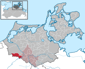
| Location of the community of Dettmannsdorf in the Vorpommern-Rügen district | ||
  |
||

Dettmannsdorf is a municipality in the Mecklenburg part of the Vorpommern-Rügen district . It is located southwest of Ribnitz-Damgarten on the Recknitz valley . Until January 1, 1999 the community belonged to the Bad Sülze office and is now part of the Recknitz-Trebeltal office .
Geography and traffic
Dettmannsdorf is about 25 kilometers east of the Hanseatic city of Rostock and about nine kilometers west of Bad Sülze . The federal motorway 20 , which runs south of the municipality, can be reached via the Tribsees , Sanitz and Ticino junctions .
Larger municipal areas are forested, the forest area Dettmannsdorfer Wüstung in the west of the municipality should be mentioned here. In the south the community borders on the Recknitz, there are no larger lakes in the community area. In the northwest is the Dammerstorfer Moor and in the south the Maibachtal nature reserve .
Districts
The districts belong to the municipality:
|
|
history
On July 1, 1950, the previously independent communities Kölzow and Wöpkendorf were incorporated.
The community was part of the Rostock office until 1952 and then belonged to the Ribnitz-Damgarten district in the Rostock district until 1994 .
Koelzow
Kölzow was first mentioned in a document in 1233. The church dates from 1205.
Dudendorf
The Dudendorf estate was first mentioned in the 15th century, when it was a subsidiary estate of Liepen and belonged to the von der Lühe family. Baron Waiz von Eschen bought it in 1765. The manor house was built in the second half of the 19th century in the Tudor style. The estate remained in the family until Sigismund Wilhelm Friedrich Carl Baron Waiz von Eschen sold it in 1886 to the economic manager Paul Andreae, the son of Abraham Andreae . Under his leadership, a new modern distillery was built and the use of machines was promoted. A field railway received its own switch on the Bad Sülze – Rostock railway line. At that time, the estate covered around 850 hectares . After Paul Andreae's death in 1916, his son Brami Andreae took over the estate. He was represented by an economic manager until his return from the First World War and succeeded his father in 1918. He continued the work under the difficult conditions of the global economic crisis. Brami Andreae was shot on May 1, 1945 after the invasion of the Red Army in the manor house, the family was in the wake of land reform expropriated and holding in a state owned property converted. After 1989 the property was managed by the Treuhandanstalt , the Andreae family did not manage to return the property to the family.
In 1994 the Treuhand sold the property to a private individual who operates agriculture there. The population fell from around 100 to around 20 in 2018, and the infrastructure fell into disrepair.
Since January 1, 2001, Dudendorf has been part of the Dettmannsdorf community.
politics
Coat of arms, flag, official seal
The municipality has no officially approved national emblem, neither a coat of arms nor a flag. The official seal is the small state seal with the coat of arms of the state of Mecklenburg. It shows a looking bull's head with torn off neck fur and crown and the inscription "GEMEINDE DETTMANNSDORF".
Attractions
- Kölzow village church , built in 1205 as a stone church ; the pastor and emigrant Adolf Fuchs worked at this church during the pre-March period .
- Kölzow mansion: built around 1850 by the von Prollius family on the site of the von der Lühe family's older manor houses. In 1925 it became the summer residence of Prince Friedrich Sigismund of Prussia and remained in the family's possession until 1945. In 2000 the von der Lühe family bought the property and restored the manor house.
- The Kucksdorfer Burg is a Slavic refuge (ring wall) on the Recknitz on the border with Redderstorf .
- Manor house in Dudendorf: Built around 1850 in the neo-Gothic Tudor style , it is now privately owned and used as a farm.
- Dammerstorf tower hill
- Dettmannsdorf tower hill
- Tower Hill Kölzow
- Manor Dettmannsdorf privately owned since 2006
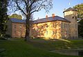
Kölzow Castle

Manor Dudendorf

Kölzow village church


Personalities
- Jonas Nicolai (* 1579 in Kölzow, † 1646 in Lübeck), pastor at Lübeck Cathedral
- Ottilie Fuchs Goeth (* 1836 in Kölzow; † 1926 in Blanco County , Texas ), German-American author
- Bernd Andreae (* 1923 in Rostock; † 1985 in Berlin), agricultural scientist and agronomist, grew up on Gut Dudendorf
Web links
Individual evidence
- ↑ Statistisches Amt MV - population status of the districts, offices and municipalities 2019 (XLS file) (official population figures in the update of the 2011 census) ( help ).
- ↑ Reading version of the main statute of the community of Dettmannsdorf. (PDF; 113 kB) (No longer available online.) Dettmannsdorf community, November 25, 2015, archived from the original on January 22, 2016 ; accessed on January 22, 2016 . Info: The archive link was inserted automatically and has not yet been checked. Please check the original and archive link according to the instructions and then remove this notice.
- ^ Historical contributions of the rural community Dettmannsdorf , 2nd edition 2008 Compiled by Heike Wiemann
- ^ Special print from the Kaiserwerk der Landwirtschaft. German agriculture under Kaiser Wilhelm II. Carl Marhold Verlagbuchhandlung 1913.
- ^ Gutshaus Dudendorf , gutshaeuser.de, accessed on December 8, 2019.
- ↑ Carolin Riemer: "Dudendorf dies". ostsee-zeitung.de, February 21, 2018, accessed on December 7, 2019.
- ↑ StBA: Changes in the municipalities in Germany, see 2001
- ↑ Main Statute, Section 1, Paragraph 2

Ahrenshagen-Daskow | Ahrenshoop | Altefähr | Altenkirchen | Altenpleen | Baabe | Bad Sülze | Barth | Mountains on Rügen | Binz | Born a. Darß | Breege | Buschvitz | Dettmannsdorf | Deyelsdorf | Dierhagen | Divitz-Spoldershagen | Dranske | Drechow | Dreschvitz | Eixen | Elmenhorst | Franzburg | Fuhlendorf | Garz / Rügen | Went | Glewitz | Glowe | Goehren | Grammendorf | Gransgebieth | Gremersdorf-Buchholz | Grim | Groß Kordshagen | Gross Mohrdorf | Gustow | Hugoldsdorf | Hiddensee Island | Jakobsdorf | Karnin | Kenz-Küstrow | Klausdorf | Kluis | Kramerhof | Lancken-Granitz | Lietzow | Lime wood | Löbnitz | Lohme | Lüdershagen | Lüssow | Marlow | Millienhagen-Oebelitz | Mönchgut | Neuenkirchen | Niepars | Pantelitz | Papenhagen | Parchtitz | Patzig | Poseritz | Preetz | Prerow | Prohn | Pruchten | Putbus | Putgarten | Ralswiek | Rambin | Rappin | Ribnitz-Damgarten | Richtenberg | Hall | Sagard | Velvet | Sassnitz | Schaprode | Schlemmin | Sehlen | Sellin | Semlow | Splietsdorf | Steinhagen | Stralsund | Süderholz | Sundhagen | Trent | Tribsees | Trinwillershagen | Ummanz | Velgast | Weitenhagen | Wendisch Baggendorf | Wendorf | Wieck a. Darß | Wiek | Wittenhagen | Wustrow | Zarrendorf | Zingst | Zirkow