Buschvitz
| coat of arms | Germany map | |
|---|---|---|

|
Coordinates: 54 ° 26 ' N , 13 ° 28' E |
|
| Basic data | ||
| State : | Mecklenburg-Western Pomerania | |
| County : | Western Pomerania-Ruegen | |
| Office : | Mountains on Rügen | |
| Height : | 8 m above sea level NHN | |
| Area : | 10.14 km 2 | |
| Residents: | 259 (Dec. 31, 2019) | |
| Population density : | 26 inhabitants per km 2 | |
| Postal code : | 18528 | |
| Area code : | 03838 | |
| License plate : | VR, GMN, NVP, RDG, RÜG | |
| Community key : | 13 0 73 014 | |
| LOCODE : | DE BAT | |
| Office administration address: | Am Markt 5–6 18528 Bergen on Rügen |
|
| Website : | ||
| Mayor : | Malte Preuhs (BFR) | |
| Location of the municipality of Buschvitz in the district of Vorpommern-Rügen | ||
Buschvitz is a German municipality in the district of Vorpommern-Rügen on the island of Rügen in Mecklenburg-Western Pomerania. The municipality is administered by the Bergen auf Rügen office based in the city of the same name .
Geography and traffic
Buschvitz is located about 5 km northeast of Bergen on Rügen on a district road. The federal highway 196 runs south of the community. The B 96 leads through the municipality of Buschvitz, past the villages of Prisvitz and Strüßendorf, which are also on the Stralsund – Sassnitz railway line . In the municipality of Buschvitz near the village of Strüßendorf in corridor 1 on parcel 53 is the calculated geographical center of the island of Rügen. The place is on the edge of the motherland on the Kleiner Jasmunder Bodden . The lake and the fen area of the Ossen are located in the municipality .
The districts of the community are Buschvitz, Prisvitz, Stedar and Strüssendorf.
history
The area was part of the Principality of Rügen until 1326 and then the Duchy of Pomerania . With the Peace of Westphalia of 1648, Rügen and thus also the area of Buschvitz became part of Swedish Pomerania . In 1815, Buschvitz came to the Prussian province of Pomerania as part of New Western Pomerania .
Since 1818, Buschvitz has belonged to the district of Rügen . Only in the years from 1952 to 1955 was it part of the Bergen district. The community then belonged to the Rügen district in the Rostock district until 1990 and became part of the state of Mecklenburg-Western Pomerania in the same year. The district of Rügen, which has been called this again since 1990, was merged in 2011 in the district of Vorpommern-Rügen.
Coat of arms, flag, official seal
The municipality has no officially approved national emblem, neither a coat of arms nor a flag . The official seal is the small state seal with the coat of arms of the region of Western Pomerania . It shows an upright griffin with a raised tail and the inscription "GEMEINDE BUSCHVITZ".
Attractions
- Small Jasmunder Bodden in front of the Pulitz peninsula
- Barrows field northwest of the village of Buschvitz
- Circular hiking trail under an avenue of beech trees on the Pulitz peninsula (entry is prohibited from January 15 to July 15, as there is a sea eagle nest in the immediate vicinity of the hiking trail)
- Ossen (small lake near the district of Stedar as a bird sanctuary)
- The center of Buschvitz consists of former boutiques and fishermen's houses (rectangular, pressed architectural style, mostly half-timbered with a thatched roof)
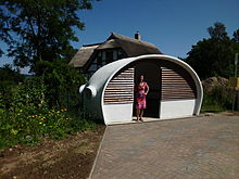
- Bus stop in Buschvitz, hyper shell construction in the form of a diving helmet (built in 1974 by the Müther company, Binz)
Web links
Individual evidence
- ↑ Statistisches Amt MV - population status of the districts, offices and municipalities 2019 (XLS file) (official population figures in the update of the 2011 census) ( help ).
- ↑ Main Statute, Section 1, Paragraph 2 (PDF).


