
Rambin
| coat of arms | Germany map | |
|---|---|---|

|
Coordinates: 54 ° 21 ' N , 13 ° 12' E |
|
| Basic data | ||
| State : | Mecklenburg-Western Pomerania | |
| County : | Western Pomerania-Ruegen | |
| Office : | West Ruegen | |
| Height : | 5 m above sea level NHN | |
| Area : | 31.43 km 2 | |
| Residents: | 954 (Dec. 31, 2019) | |
| Population density : | 30 inhabitants per km 2 | |
| Postal code : | 18573 | |
| Area code : | 038306 | |
| License plate : | VR, GMN, NVP, RDG, RÜG | |
| Community key : | 13 0 73 073 | |
| Office administration address: | Dorfplatz 2 18573 Samtens |
|
| Website : | ||
| Mayor : | Andreas Klug | |
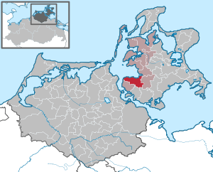
| Location of the municipality of Rambin in the district of Western Pomerania-Rügen | ||
  |
||

Rambin is a municipality on the island of Rügen in Mecklenburg-Western Pomerania. The municipality belonging to the district of Vorpommern-Rügen is administered by the West-Rügen office with its seat in the municipality of Samtens .
location
_2.JPG)
Rambin is located about twelve kilometers northeast of Stralsund and about 18 kilometers southwest of Bergen.
The B 96 and the Stralsund – Sassnitz railway run through the community. In the north, the community borders the Kubitzer Bodden and the Western Pomerania Lagoon Area National Park .
Districts
The municipality of Rambin includes the towns of Kasselvitz, Giesendorf, Breesen, Gurvitz, Bessin, Grabitz, Götemitz, Drammendorf, Rothenkirchen, Sellentin and Neuendorf.
history
Rambin was first mentioned as Rabyn in 1246 . The place name is of Slavic origin. The Stralsund councilor Godeke von Wickede founded a hospital and infirmary here in 1334. As early as the 14th century, several owners shared the place: the Duke of Pomerania, the hospital and infirmary St. Jürgen vor Rambin and the pastorate.
The place was part of the Principality of Rügen until 1326 and then the Duchy of Pomerania . With the Peace of Westphalia of 1648, Rügen and thus also the area of Rambin became part of Swedish Pomerania . In 1815 Rambin came to the Prussian province of Pomerania as part of New Western Pomerania .
Since 1818 Rambin has belonged to the district of Rügen . In the GDR period , 1952 to 1955, it belonged to the Putbus district, after which it was incorporated into the Rügen district in the Rostock district . After reunification and the formation of new federal states , Rambin became part of the state of Mecklenburg-Western Pomerania in 1990. The district of Rügen, which was also called this again, was added to the district of Vorpommern-Rügen in 2011.
economy
Rambin lives mainly from tourism. The Rügener Insel brewery, founded in 2014, makes a significant contribution to this .
coat of arms
The coat of arms designed by Michael Zapfe from Weimar was approved by the Ministry of the Interior on May 17, 1999 and registered under the number 187 of the coat of arms of Mecklenburg-Western Pomerania.
Blazon : “In blue, a golden Roman warrior with a silver shield covered with a red cross and a silver sword on his belt, sitting on a silver jumping horse, piercing a winged golden dragon with a silver lance; in the upper left corner a silver shield, on it a red Aesculapian staff with a red-tongued black snake. "
Attractions

- St. Jürgen Monastery from the 14th century
- historical village center
- Gothic brick church of St. John from the 14th century
- Provener house
- Bessin Chapel of the Holy Cross from 1482
- Local history museum with the permanent exhibition Life and Work in the Country
Web links
- Literature about Rambin in the state bibliography MV
- Community website
- Municipality of Rambin on the website of the West-Rügen Office
Individual evidence
- ↑ Statistisches Amt MV - population status of the districts, offices and municipalities 2019 (XLS file) (official population figures in the update of the 2011 census) ( help ).
- ↑ Main statute of the municipality of Rambin from 02.26.2015. (PDF; 1.3 MB) February 26, 2015, accessed December 21, 2017 .

Ahrenshagen-Daskow | Ahrenshoop | Altefähr | Altenkirchen | Altenpleen | Baabe | Bad Sülze | Barth | Mountains on Rügen | Binz | Born a. Darß | Breege | Buschvitz | Dettmannsdorf | Deyelsdorf | Dierhagen | Divitz-Spoldershagen | Dranske | Drechow | Dreschvitz | Eixen | Elmenhorst | Franzburg | Fuhlendorf | Garz / Rügen | Went | Glewitz | Glowe | Goehren | Grammendorf | Gransgebieth | Gremersdorf-Buchholz | Grim | Groß Kordshagen | Gross Mohrdorf | Gustow | Hugoldsdorf | Hiddensee Island | Jakobsdorf | Karnin | Kenz-Küstrow | Klausdorf | Kluis | Kramerhof | Lancken-Granitz | Lietzow | Lime wood | Löbnitz | Lohme | Lüdershagen | Lüssow | Marlow | Millienhagen-Oebelitz | Mönchgut | Neuenkirchen | Niepars | Pantelitz | Papenhagen | Parchtitz | Patzig | Poseritz | Preetz | Prerow | Prohn | Pruchten | Putbus | Putgarten | Ralswiek | Rambin | Rappin | Ribnitz-Damgarten | Richtenberg | Hall | Sagard | Velvet | Sassnitz | Schaprode | Schlemmin | Sehlen | Sellin | Semlow | Splietsdorf | Steinhagen | Stralsund | Süderholz | Sundhagen | Trent | Tribsees | Trinwillershagen | Ummanz | Velgast | Weitenhagen | Wendisch Baggendorf | Wendorf | Wieck a. Darß | Wiek | Wittenhagen | Wustrow | Zarrendorf | Zingst | Zirkow