
West Rügen Office
| coat of arms | Germany map | |
|---|---|---|

|
Coordinates: 54 ° 28 ' N , 13 ° 11' E |
|
| Basic data | ||
| State : | Mecklenburg-Western Pomerania | |
| County : | Western Pomerania-Ruegen | |
| Area : | 290.21 km 2 | |
| Residents: | 9444 (Dec. 31, 2019) | |
| Population density : | 33 inhabitants per km 2 | |
| License plate : | VR, GMN, NVP, RDG, RÜG | |
| Office key : | 13 0 73 5362 | |
| Office structure: | 11 municipalities | |
| Office administration address : |
Dorfplatz 2 18573 Samtens |
|
| Website : | ||
| Head of Office : | Edelgard Feichtiger | |
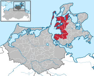
| Location of the West-Rügen office in the Vorpommern-Rügen district | ||
  |
||

In the West-Rügen Office , based in the municipality of Samtens , eleven municipalities are united to deal with their administrative business. It is named after the location on the island of Rügen in the Vorpommern-Rügen district in Mecklenburg-Western Pomerania (Germany).
On January 1, 2005, the West-Rügen Office was re-established from the former offices of Gingst and South-West Rügen and the formerly free municipality of Insel Hiddensee .
Starting from the center of Rügen, the official area comprises several peninsulas that extend to the west, north-west and north. These foothills are separated only by narrow straits from the Bug and Wittow peninsulas and from the ferry island ( Hiddensee sub- island ). The office also includes the islands of Hiddensee, Ummanz and the smaller islands of Heuwiese , Liebitz , Öhe and the ferry island. The official area is predominantly agricultural, but tourism is playing an increasingly important role - it is the main source of income on Hiddensee. In the south, the West-Rügen Office has a share in Strelasund , opposite the city of Stralsund , with which Rügen is connected by the Rügen dam . Large parts of the official area are part of the Vorpommersche Boddenlandschaft National Park .
In the south the federal highway 96 and the railway line Stralsund - Sassnitz cross the administrative area.
The municipalities with their districts
- Altefähr with Barnkevitz, Grahlhof, Jarkvitz, Klein Bandelvitz, Kransdorf, Poppelvitz and Scharpitz
- Dreschvitz with Bußvitz, Dußvitz, Güttin, Liebitz Island (uninhabited), Landow, Mölln, Ralow and Rugenhof
- Went with Güstin, Haidhof, Kapelle, Malkvitz, Presnitz, Teschvitz and Volsvitz
- Hiddensee island with greaves, monastery, Neuendorf and Vitte
- Kluis with Gagern, Pansevitz and Silenz
- Neuenkirchen with Breetz, Grubnow, Laase, Lebbin, Liddow, Moor, Moritzhagen, Neuendorf, Reetz, Tribbevitz, Vieregge and Zessin
- Rambin with Bessin, Breesen, Drammendorf, Götemitz, Grabitz, Kasselvitz, Rothenkirchen and Sellentin
- Samtens with Berglase, Dönkvitz, Frankenthal, Muhlitz, Natzevitz, Negast, Sehrow, Stönkvitz, Tolkmitz and Zirkow Hof
- Schaprode with Charlottendorf, Granskevitz, Insel Öhe , Lehsten, Neuholstein, Poggenhof, Retelitz, Seehof, Streu and Udars
- Trent with the fishing settlement, Freesen, Ganschvitz, Grosow, Holstenhagen, Jabelitz, Libnitz, Tribkevitz, Vaschvitz, Venz and Zubzow
- Ummanz with Dubkevitz, Freesenort , Groß Kubitz, Haide, Lieschow, Lüßvitz, Moordorf, Mursewiek, Suhrendorf, Tankow, Unrow, Varbelvitz, Waase and Wusse as well as the island of Heuwiese
supporting documents
- ↑ Statistisches Amt MV - population status of the districts, offices and municipalities 2019 (XLS file) (official population figures in the update of the 2011 census) ( help ).