
Ummanz
| Ummanz | ||
|---|---|---|
 |
||
| Waters | Baltic Sea | |
| Geographical location | 54 ° 28 '27 " N , 13 ° 10' 24" E | |
|
||
| surface | 20 km² | |
| Highest elevation | 6.7 m | |
| Residents | 274 14 inhabitants / km² |
|
| main place | Waase | |
 |
||

The island of Ummanz is located in the Baltic Sea , offshore to the west of the island of Rügen and, like it, belongs to the district of Vorpommern-Rügen in the German state of Mecklenburg-Western Pomerania .
Ummanz is around 20 square kilometers, making it the second largest island in the former Rügen district after Rügen. It is part of the Vorpommersche Boddenlandschaft National Park . The island is bounded in the west and northwest by the Schaproder Bodden , in the north by the Udarser Wiek , in the east by the Koselower See and in the south by Die Breite . The island of Ummanz is very flat. The highest point is in Suhrendorf and is only 6.7 meters above sea level. NN .
The island has been connected to the island of Rügen by a 250 meter long bridge since 1901. The largest town on the island is the church village Waase , and the small towns of Haide, Markow, Suhrendorf, Freesenort , Tankow and Wusse are also located on Ummanz . Together with some of the villages on Rügen, they form the municipality of Ummanz .
From 1341 on, the island was owned by the Heiliggeisthospital in Stralsund . Thus, on behalf of the church foundation, Stralsund citizens ruled the island for centuries.
In the district of Suhrendorf there is a campsite with a view of Hiddensee , which surfers and kiters especially prefer.

Rügen-Ummanz bridge

Museum and ceramic workshop Waase on Ummanz
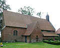
Evangelical St. Marien Church in Waase on Ummanz

Plattenweg on Ummanz


Web links

Ahrendsberg | Balmer Werder | Barther Oie | Baumwerder | Beuchel | Buck | Bull reef | Böhmke | Brinkenberg | Dänholm (near Kröslin) | Dänholm (near Stralsund) | Ferry Island | Fehmarn | Gänsewerder | Görmitz | Greifswalder Oie | Big Werder | Big Wotig | Grot Deil | Hay meadow | Hiddensee | Kastenwerder | Kiel place | Kirr | Small pipe plan | Little Werder | Little Wotig | Little Werder | Kohlhof Island | Koos | Langenwerder | Dear | Liebitz | Moravia | Oe | Poel | Prosnitzer Werder | Riems | Riether Werder | Reefbrink | Ruden | Rügen | Tedingsinsel | Tollow | Ummanz | Urkevitz | Usedom | Vilm | Bird Island | Whale | Warder | Willow tail | Werder | Wührens