Vilm
Vilm [ film ] is a German island in the Baltic Sea . It is located off the south coast of the island of Rügen in the state of Mecklenburg-Western Pomerania . Vilm belongs to the town of Putbus on Rügen and is part of the island Vilm nature reserve . The name is derived from the Slavic ilumu and means elm .
geography
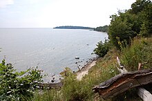
The island is located in the Rügischer Bodden , three kilometers southeast of Lauterbach on Rügen and 20 kilometers from the mainland. It is 0.94 km², has a length of 2.5 km, and its highest point is 37.8 meters above sea level. Almost all coastal forms of the southern Baltic Sea occur on Vilm, and their nature is characterized by great biodiversity. The cliffs are subject to constant changes due to erosion, while sand and gravel are landed in other places. Most of the vegetation consists of natural beech and oak trees. The island has been under nature protection since 1936 and has been part of the Southeast Rügen Biosphere Reserve since 1990 . It is also a European bird sanctuary and FFH area ( Fauna-Flora-Habitat Directive ) under EU law. There are only a few houses that are used by nature conservation institutions.
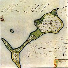
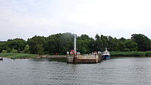
The island is divided into three parts. In the north is the Great Vilm, on which the highest elevation is located. This is followed by the narrow Mittelvilm to the southwest, which connects to the southern part of the island, the Kleiner Vilm. At the northern tip of the Vilms is the large hook protruding into the bay . The east bank of the Großer Vilms is known as the Kochufer . To the south stretches to the shore by the chef includes Knirkberg extending Large Vilmbucht on. The bay in the area of the transition from Mittelvilm to Kleiner Vilm on the east side is called Kleine Vilmbucht. The southernmost point of the Kleiner Vilms and thus the entire island is called Schneider or Der Schneider . The south-west bank of the Kleiner Vilms is called Die Scheibe . To the north of this, the Kleine Haken extends into the sea. The bay Am Ruptin or Ruptin stretches between the Kleiner Haken and the Mittelvilm . The bank area is known as Blank Hell . To the north of this is the Vossberg . In the water in front of the west bank at the transition from Mittelvilm to Großer Vilm, the brothers , probably two boulders in front of the bank, are drawn in older maps . On the west side of the Großer Vilms, on the Karkenufer, is the island's landing stage. The Green Mountain is located on the Großer Vilm . While in older maps, but also in more recent literature, an elevation on the western steep bank is called this, the highest elevation in the interior of the Great Vilms bears this name on current maps.
To the northwest of the island is the Schnakenwerder shoal , which existed as an island in the 19th century. The Waschstein boulder is located close to the southeastern bank . Another boulder, designated as a geotope but unnamed, is located on the Kleiner Vilm near the southern tip of the island. The Great Hook, the active steep banks on the Great and Small Vilm, a fossil cliff on the Great Vilm, and an active section of cliff near the Small Hook are also designated as geotopes on Vilm.
About 2.8 kilometers east of Vilm is an artificial island in the Rügischer Bodden, which the People's Navy of the GDR used to demagnetize their ships. Today it is a ruin populated by sea birds.
history
Prehistory and the Middle Ages
Vilm was formed from glacial moraines around 10,000 years ago . There is evidence that the island was inhabited as early as the Stone Age. Finds from the Middle and Neolithic were made. In addition, there are remains of a Neolithic megalithic grave on the top of the Great Vilms . 3000 years ago Vilm separated from the island of Rügen. For the Slavs , Vilm was a sacred place. The island was first mentioned in a document in 1249. 250 years earlier, around the year 1000, the island must have been known to the Vikings . The naval battle of Svoldr , mentioned in Nordic lore , which was fought on September 9, 1000 between the Norwegians under King Olav I Tryggvason and a united Danish-Swedish naval power under kings Sven Gabelbart and Olof Skötkonung in league with the Jomswikings , could be the latest research according to have taken place in the sea area of the island of Vilm. The Norwegians were annihilated, and the power of the Jomsvikings was also on the decline.
The Vilm has been owned by the Putbus family since 1249 . During the All Saints Flood in 1304 , the shape of the island changed, although the nature of the change is unclear. There are suspicions that the separation from the island of Rügen only took place at this point in time. Even later, Vilm was surrounded by several smaller islands. In 1371 several islands ( lutken Werderen ) are mentioned, but they gradually disappeared until the last one was flooded with the Schnakenwerder.
Vilmer Chapel
In 1336 the Vilmer Chapel already existed on the island , which was at times important as a place of pilgrimage and served as a coastal station for the care of the sick. There was a farm on which at least three hermits lived. After a pilgrimage accident in front of Palmer Ort with 90 dead in 1372, the pilgrimages came to a temporary end. In 1396 four hermits came to the island. The chapel was repaired again. To the south of the churchyard, the hermits were allocated an area of 15 square rods for the construction of apartments. More hermits followed later. In 1490 the chapel was again threatened with decay. On September 22nd, 1494 the altar of what was probably a largely newly built chapel was consecrated. With the introduction of the Reformation , the chapel lost its importance and was given up. The final demolition took place in the 18th century. Today (as of 2013) a cross reminds of the chapel.
Economic use of the island
The Putbus house used the Vilm as a summer pasture . A document from 1358 shows that the chaplain Amelung von der Lippe, who lives on Vilm, was granted the right to protect his meadows with a ditch and his yard with a fence as protection from the cattle. Even after the end of the chapel, the homestead on the Vilm was still used and leased from the Putbus house. In the course of the 18th century, the courtyard is said to have been desolate for a while . From a document book from 1767, however, five residents again emerge.
Until the beginning of the 16th century, the island forest was also used for logging. The last major logging took place in 1527. The widow of Waldemar II zu Putbus, who died shortly before, sold the wood on the island in 1527 after a wind break for the considerable price of 400 marks Sundisch and a load of Seebier to Stralsund merchants. At the same time, the right to log was limited to 10 years. Total deforestation , however, was contractually prohibited. 60 designated by the widow Hege trees , the trees at the chapel and had to stay in the garden. The conservation trees were supposed to protect the grazing animals and especially the acorns . These very old trees later became one of the island's attractions. The Stralsund merchants were also allowed to keep six horses on Vilm to transport the wood to the ships. Accommodation was created for the woodworkers. They were also allowed to keep four dairy cows and two slaughter cattle, whereby the animals were not allowed to be too big so that they would not be dangerous to the mistress of Putbus, who was also temporarily staying at Vilm.
A first depiction of the village on a map has come down to us from 1608. An exact representation was then made in 1695 as part of the Swedish land survey of Western Pomerania . In 1678, in the Swedish-Brandenburg War , and in 1715, in the Great Northern War , landing operations to capture Rügen took place in the immediate vicinity of the Vilms, but the island itself was not affected.
In 1788 the widowed Countess Sophie Wilhelmine zu Putbus received the farm on Vilm as a widow's pension. The yard had been expanded. Next to the house there was a barn, stable and an oven . 45 cows, 8 pigs and 5 horses were kept. At least temporarily, the mother actually lived on the island with her children Wilhelm Malte zu Putbus and Moritz Carl zu Putbus . The children's educator, Karl Reyer , dedicated a poem to the Vilm.
After the last major logging in 1527, both the trees for protection and the regrowing vegetation were able to develop undisturbed into considerably old trees. The geographer Johann Jacob Grümbke visited the island and was the first to describe the unusually old and large trees in 1805. The use of wood has been completely stopped since 1812. Due to the unspoilt forest, Vilm became a frequent target and motif for painters. The forest on Vilm was considered the last primeval forest in northern Germany . During the period of French occupation from 1807 to 1813, the French wanted to deforest the Vilms. Prince Wilhelm Malte zu Putbus, who was closely associated with the Vilm through his childhood and youth, successfully campaigned against deforestation.
tourism
With the establishment of the bath house Goor in the years 1817/1818 on Rügen, not far from the Vilms, by Prince Wilhelm Malte zu Putbus, an early tourism developed in the area . Vilm was used as a destination.
From 1819 the farm on Vilm was leased from the Putbus house as a dairy . For the tenants there was an obligation to take in guests coming to the island and to entertain them for a fee. Requests for visits could be communicated to Vilm via flag signals from the Goor. The first tenant was Christoph Haase from the Zudar peninsula .
It was reported that life on the Vilm was very isolated. The painter Carl Gustav Carus visited the island in 1819. In his travel report he stated that there was only a small dairy farm on the Vilm. Its residents brought their products such as cheese, butter and ham to Greifswald for sale by ship , but had little contact with and information about the outside world. Even serious events such as Napoleon's expulsion and deposition were unknown to them.
From 1824 Karl Timm from Nadlitz and from 1834 Philipp Weidemann from Neuendorf were tenants. The forester Ludwig Witte leased the property from 1844. In addition to 69 sheep and 11 cows, he also kept 3 horses, 2 foals and 2 pigs. In addition to extensive animal husbandry, he began to develop more tourism. The old house was torn down and replaced by a new building, to which a hall was added as a salon extension for visitors. The number of visitors increased. Vilm was more commonly referred to as Capri of the Baltic Sea or Capri of the North .
In addition to the holidaymakers from Putbus and Lauterbach, locals from the surrounding area also came. They went on trips to Vilm, especially at Whitsun. In the absence of an inn, meals brought along were cooked. The area of the northeast steep bank was particularly popular, from which the name "Kochufer", which is still in use today, is said to result. In 1858 a liquor license was granted, which turned the property into an inn. In 1886 a lodging house was built because the bathing tourism from Putbus on Rügen was very active. In May 1888, a hollow oak burned down when a shepherd lit a fire inside it to make coffee. The Witte family remained tenants of the property until 1908. The tenant Fritz Beu followed. He expanded the lodging house. In 1914 it had 25 rooms. Not far from the house on the west beach of the island there were simple bathing establishments.
The crossing to the island was done with small sailing or rowing boats. From 1891 motor boats were also used. From the end of the 1920s there was a regular shipping route from Greifswald to Vilm. The connection of Lauterbach to the railway network in 1895 also resulted in significantly improved accessibility to the island. The number of visitors increased significantly. Many day tourists came now.
Early handling of the wildlife
In 1833 there were efforts to settle cormorants on Vilm. However, fishermen feared competition from the animals and drove them away with firecrackers , with cormorants living in the area today (as of 2013). The attempt to settle pheasants also failed because the animals were shot down. Released roe deer swam back to Rügen. Today (as of 2013), however, roe deer that migrate from Rügen are regularly on the island. Eagles originally lived on Vilm. In 1840 the Zoological Institute in Greifswald received a young eagle from Vilm. Several eagles shot at Vilm were stuffed . Such a copy was still in the restaurant on the island until 1900. The last eagles disappeared when in 1875 “two bad boys” brought the eagle cubs out of the eyrie. Later, in the time of the GDR , there was another eyrie with sea eagles , which however disappeared after an antenna mast was set down with a helicopter directly next to the eyrie in the 1980s during the breeding season .
Sea mark and storm flood
Vilm was of little importance as a navigation mark . In the years 1848/49, however, there was a beacon on the Mittelvilm , which was to be set on fire in the event that Danish ships came south of Thiessow to the Greifswalder Bodden in the course of the Schleswig-Holstein War . For a few years from 1848 the steep bank in the south of the island was used as a target for target practice by the navy gunboats stationed in Stralsund . The name Die Scheibe is said to go back to this usage.
With the Baltic storm flood in November 1872, a severe storm flood also hit the Vilm and led to significant changes in the landscape. The Mittelvilm was breached in two places, but both breakthroughs disappeared again. Since the island had not been affected by storm floods for a long time, inclined embankments with a thick turf had formed in the area of the high banks. As a result of the storm flood, the bank areas facing the lake on the Great and Small Vilm were demolished. Cliffs formed again. Further storm floods occurred in 1904, 1913 and 1914. This also resulted in coastal shifts of up to ten meters.
Protected position
Many old trees have old initials carved into them, including coats of arms and depictions of deer and horse. This bad habit, damaging the trees, was in use until the 1950s. The nature of the island was damaged by the large number of visitors. It was placed under nature protection on December 2, 1936 by ordinance of the Szczecin District President . However, a travel guide published in 1932 indicated that the island was under nature protection.
Development from 1945
After the Second World War , there was a serious shipwreck on October 24, 1945 in the waters off Vilm. A ship loaded with ammunition ran onto the Schnakenwerder shoal. There was an explosion in which all 81 people on board died. To this day, this sea area has been designated as a restricted area because of the old ammunition.
The Putbus house was expropriated in the course of the land reform in 1945. The island was now administered by the city of Putbus. Vilm experienced increased visitor traffic again. Up to 400 people visited the island on weekdays and over 1000 people on weekends. In 1953 the Society for Sport and Technology opened a sailing school on Vilm, but it was closed again after three years. The city of Putbus then set up a large excursion restaurant on the Vilm. In the summer, 700 day tourists visited the island regularly. The existence of the nature reserve was endangered.
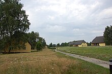
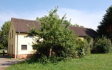
In 1959, Vilm was closed to public use and used as a vacation home for the GDR Council of Ministers . The eleven buildings in the style of a fishing settlement date from this time. There is also an administration building and farm buildings. The only older building that remained was a former stable building. Vilm was now a regular holiday destination for high-ranking GDR politicians and employees of the Council of Ministers. Also Margot and Erich Honecker visited the island a few times and stayed at number 2. The so resulting seclusion of the island turned out for nature conservation concerns as positive.
In the course of the political change in 1989 , a visit by the youth magazine ELF99 of GDR television to the island, which was previously inaccessible to the public, caused a sensation.
Foundation of the Nature Conservation Academy in 1990
On September 1, 1990, Vilm was subordinated to the newly formed GDR Ministry for the Environment, Nature Conservation, Energy and Nuclear Safety. In coordination with the government of the Federal Republic of Germany , a nature conservation academy was set up for the South Baltic . On October 6, 1990, the Academy was opened as the International Nature Conservation Academy Vilm by the Federal Environment Minister Klaus Töpfer and affiliated to the then Federal Research Institute for Nature Conservation and Landscape Ecology. Today the academy is operated as a branch office of the Federal Agency for Nature Conservation and holds conferences and seminars. Since autumn 1990 the island has been part of the Southeast Rügen Biosphere Reserve . From 1990 Vilm was reopened to the public to a limited extent: from March to October, up to 30 visitors can enter the island daily under an authorized guide.
At the beginning of the 21st century, a solar system was built in the area of the settlement .
Flora and fauna
A process of transformation from the Hudewald to a natural forest is taking place on Vilm . Two layers can often be observed in the vegetation of the forests: an upper layer consists mainly of native, gnarled beeches and oaks, a second layer is overgrown by hornbeam and sycamore maple. Since the last major logging took place in 1527, the beech forests are part of the oldest and most valuable natural forests in northern Germany. The particularly striking and old Twelve Apostles' beech collapsed in the 1950s. The old pear trees on the north-west bank are remarkable. Presumably they are descendants of the garden trees mentioned in 1527. Due to the elm disease transmitted by the elm splint beetle, the elm that gives it its name can only be found sporadically in the lower stratum, especially in forest areas. The black alder, which is otherwise often found on Rügen, is almost completely absent on Vilm, even in the bank areas. Especially in summers with little rainfall, trees on the moraine cores come under drought stress and react to a lack of water with rolled up leaves. Due to the wind, the otherwise typical leaf litter and noteworthy humus layer on the rapidly drying mineral soils are missing in many places.
A forest of birch and English oak can be found on the old beach ridges of Mittel-Vilms. The crowns of the small, entwined trees, deformed by the wind, are striking. Formerly existing sandy grassland was replaced by pioneer forest and bushes. Here are found mainly Holzapfel , blackthorn , hawthorn , wild pear and wild roses .
The island is home to over 300 fern and flowering plants, often rare, that grow in various habitats on the island. Liverwort , larkspur and wild garlic can be found in the forests of the island . Beach thistle , tartar lettuce and chickweed are found on the beaches. While timothy grass , swallowwort and saxifrage occur in warm and dry locations, the common plants of the salt marshes are the adder-tongue family , beach tricorn and milkweed . The forest honeysuckle extends as a head-high thicket over large areas of the forest floor and as a climbing plant up high into the trees.
The fauna is richly represented with small mammals, reptiles, amphibians, insects and mollusks . Birds are of particular importance. The old hollow trees in particular serve as breeding grounds for various birds such as the goosander and tawny owl . The nesting holes for sand martins and shelduck are located on the steep banks of the island . The sea eagle is again on the island . Also, cormorants and herons fish in the island surrounding lagoons. Geese, Limikolen , sawdawers , swans and swimming and diving ducks rest there in spring and autumn .
Beech marten , pine marten , roe deer and red fox can be found in mammals . From time to time, wild boars coming from Rügen also stay on Vilm.
art
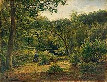
In the 19th century, Vilm was a popular object of various well-known painters. That is why the island was also called the Painters' Island at that time . By Caspar David Friedrich , the island motifs "look to the island of Vilm" (1809) and "Landscape with Rainbow" (1810) come. Friedrich Preller the Elder created the watercolor "Insel Vilm" around 1840. The oil painting “Memory of a Wooded Baltic Sea Island” by Carl Gustav Carus is also assigned to the Vilm. Johann Friedrich Rosmäler created several steel engravings from Vilm and the surrounding area in 1835. By Friedrich Preller the Younger the 1888 resulting picture is "Baltic Sea coast on the island of Vilm." It shows the view from the Kochufer on the Großer Vilm to the south to the Kleiner Vilm. In 1891 Hermann Eschke created the painting "Landscape on Vilm". Later, the painter Katharina Bamberg also worked on Vilm.
The poet Ernst Moritz Arndt mentioned the Vilm in his poem The Swan von Pulitz . Gerhart Hauptmann made notes on his fragment Helios that refer to Vilm. In his novel Vortex of Vocation , the notes are used to depict an island.
literature
- Ernst Assmann : The scenes of the Danish-Wendish fighting in the waters of Rügen. In: Baltic Studies . Vol. 43, Hamburg 1955, pp. 21-41.
- Norbert Buske : Vilm - The story of an island. thomasius verlag , Schwerin 1994, ISBN 3-931185-13-3 .
- Hans Dieter Knapp: Vilm Island, nature reserve in the Southeast Rügen Biosphere Reserve. Federal Agency for Nature Conservation, leaflet, September 2012.
- The Greifswalder Bodden - field of tension between feudal powers. In: Lutz Mohr : Between Danish and Gristower Wiek. The Greifswald suburb of Wieck, the Great Stubber and the Greifswalder Bodden. (= New Greifswald Museum Issues . No. 4). Greifswald 1978, DNB 790676729 .
- Lutz Mohr : On the Viking King Battle of Svoldr on the Pomeranian coast on September 9, 1000. In: Heimathefte for Mecklenburg-Western Pomerania. Vol. 4, Schwerin 1993, pp. 31-39.
Individual evidence
- ↑ Norbert Buske: Vilm - The story of an island. thomasius verlag , 1994, pp. 12 and 35.
- ↑ Geotope registration document: Findling Insel Vilm. (PDF; 7 kB) State Office for the Environment, Nature Conservation and Geology Mecklenburg-Western Pomerania , accessed on August 13, 2013 .
- ↑ Geotope registration document: Kliffinsel Vilm. (PDF; 7 kB) State Office for the Environment, Nature Conservation and Geology Mecklenburg-Western Pomerania , accessed on August 13, 2013 .
- ↑ Geotope registration document: Cliff from the litorina period. (PDF; 7 kB) State Office for the Environment, Nature Conservation and Geology Mecklenburg-Western Pomerania , accessed on August 19, 2013 .
- ↑ Geotope registration document: active cliff section north of Schwarbe. (PDF; 7 kB) State Office for the Environment, Nature Conservation and Geology Mecklenburg-Western Pomerania , accessed on August 19, 2013 .
- ^ Frank Pergande: The island of Vilm. In: Frankfurter Allgemeine Zeitung. July 2, 2009.
- ↑ Norbert Buske: Vilm - The story of an island. thomasius verlag, 1994, pp. 8 and 16.
- ^ Hans Dieter Knapp: Isle of Vilm, nature reserve in the biosphere reserve of Southeast Rügen. Federal Agency for Nature Conservation, leaflet September 2012.
- ^ Rejecting Norbert Buske: Vilm - The story of an island. thomasius verlag, Schwerin 1994, p. 13.
- ↑ Norbert Buske: Vilm - The story of an island. thomasius verlag, Schwerin 1994, p. 31.
- ↑ Norbert Buske: Vilm - The story of an island. thomasius verlag, Schwerin 1994, p. 36.
- ↑ Norbert Buske: Vilm - The story of an island. thomasius verlag, Schwerin 1994, p. 60.
- ↑ Norbert Buske: Vilm - The story of an island. thomasius verlag, Schwerin 1994, p. 76.
- ↑ Norbert Buske: Vilm - The story of an island. thomasius verlag, 1994, pp. 16 and 75.
- ↑ Norbert Buske: Vilm - The story of an island. thomasius verlag, Schwerin 1994, p. 86.
- ^ Wolfgang Müller: Schiffsschicksale Ostsee 1945. Koehlers Verlagsgesellschaft, Hamburg 2001, ISBN 3-7822-0612-6 .
- ↑ Federal Maritime and Hydrographic Agency: German and Polish coast from Rostock to Gaski. Hamburg 1991, chart number 1578.
- ↑ Information from the Lenz shipping company at http://vilmexkursion.de/
- ^ Hans Dieter Knapp: Isle of Vilm, nature reserve in the biosphere reserve of Southeast Rügen. Federal Agency for Nature Conservation, leaflet September 2012.
- ↑ Norbert Buske: Vilm - The story of an island. thomasius verlag, 1994, p. 79.
Web links
- Literature about Vilm in the state bibliography MV
- International Academy of Nature Conservation Vilm Island
Coordinates: 54 ° 19 ′ N , 13 ° 32 ′ E

