
Splietsdorf
| coat of arms | Germany map | |
|---|---|---|

|
Coordinates: 54 ° 7 ' N , 12 ° 56' E |
|
| Basic data | ||
| State : | Mecklenburg-Western Pomerania | |
| County : | Western Pomerania-Ruegen | |
| Office : | Franzburg-Richtenberg | |
| Height : | 14 m above sea level NHN | |
| Area : | 26.29 km 2 | |
| Residents: | 460 (December 31, 2019) | |
| Population density : | 17 inhabitants per km 2 | |
| Postal code : | 18513 | |
| Area code : | 038325 | |
| License plate : | VR, GMN, NVP, RDG, RÜG | |
| Community key : | 13 0 73 086 | |
| LOCODE : | DE SMV | |
| Office administration address: | Ernst-Thälmann-Str. 71 18461 Franzburg |
|
| Website : | ||
| Mayor : | Burghard Rübcke from Veltheim | |
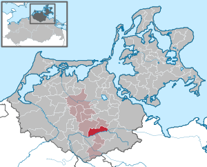
| Location of the municipality of Splietsdorf in the Vorpommern-Rügen district | ||
  |
||

Splietsdorf is a municipality west of Grimmen in the district of Vorpommern-Rügen . The community belonged to the then dissolved Trebeltal Office until January 1, 2004 and has since been administered by the Franzburg-Richtenberg Office , based in the city of Franzburg .
Geography and traffic
Splietsdorf is about ten kilometers northwest of Grimmen. The federal motorway 20 runs south of the municipality and can be reached via the Grimmen-West connection (approx. 13 km). The river Trebel flows through the south of the municipality .
Districts
|
Splietsdorf was part of the Grimmen district until 1952 and then belonged to the Grimmen district in the Rostock district until 1994 . Since 1990 the place belongs to the state of Mecklenburg-Western Pomerania.
history
Splietsdorf : Historical finds show that the area was settled early on. With the Peace of Westphalia of 1648, Vorpommern and thus Splietsdorf came under Swedish rule, after the place had previously belonged to the Duchy of Pomerania . In 1815 the municipality and Western Pomerania became part of the Prussian province of Pomerania .
Quitzin : The name changed from Kučin to Quitsin (1320-1323), Quissin (1618) and Quitzin (since 1631). A castle rampart from the 13th century in the immediate vicinity of today's castle indicates an early settlement.
The manor house was first mentioned around 1457 and rebuilt in 1607 on the vault of the castle complex, rebuilt in a Baroque style in 1723 and renovated after 1990. The castle chapel dates from 1614.
Vorland : The Vorland church was built in the 13th century and restored in 1887.
Coat of arms, flag, official seal
The municipality has no officially approved national emblem, neither a coat of arms nor a flag . The official seal is the small state seal with the coat of arms of the region of Western Pomerania . It shows an upright griffin with a raised tail and the inscription "GEMEINDE SPLIETSDORF * LANDKREIS VORPOMMERN-RÜGEN".
Attractions
→ See also the list of architectural monuments in Splietsdorf
- Church foreshore
-
Quitzin Hunting Lodge from 1607 and 1723
- Castle chapel on the Quitzin estate
- Manor house with park in Splietsdorf
- Tower hill foreland
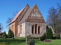
Church in foreshore, view of the choir and nave

Foreland, memorial stone for those who died in the World War
.JPG)
.JPG)
.JPG)
Web links
Individual evidence
- ↑ Statistisches Amt MV - population status of the districts, offices and municipalities 2019 (XLS file) (official population figures in the update of the 2011 census) ( help ).
- ^ Manfred Niemeyer: Greifswald contributions to toponymy VII. District of Northern Pomerania. Druckhaus Panzig, Greifswald 2007, ISBN 3-86006-266-2 , p. 109
- ↑ Main statutes, Section 1, Paragraph 2 (PDF).

Ahrenshagen-Daskow | Ahrenshoop | Altefähr | Altenkirchen | Altenpleen | Baabe | Bad Sülze | Barth | Mountains on Rügen | Binz | Born a. Darß | Breege | Buschvitz | Dettmannsdorf | Deyelsdorf | Dierhagen | Divitz-Spoldershagen | Dranske | Drechow | Dreschvitz | Eixen | Elmenhorst | Franzburg | Fuhlendorf | Garz / Rügen | Went | Glewitz | Glowe | Goehren | Grammendorf | Gransgebieth | Gremersdorf-Buchholz | Grim | Groß Kordshagen | Gross Mohrdorf | Gustow | Hugoldsdorf | Hiddensee Island | Jakobsdorf | Karnin | Kenz-Küstrow | Klausdorf | Kluis | Kramerhof | Lancken-Granitz | Lietzow | Lime wood | Löbnitz | Lohme | Lüdershagen | Lüssow | Marlow | Millienhagen-Oebelitz | Mönchgut | Neuenkirchen | Niepars | Pantelitz | Papenhagen | Parchtitz | Patzig | Poseritz | Preetz | Prerow | Prohn | Pruchten | Putbus | Putgarten | Ralswiek | Rambin | Rappin | Ribnitz-Damgarten | Richtenberg | Hall | Sagard | Velvet | Sassnitz | Schaprode | Schlemmin | Sehlen | Sellin | Semlow | Splietsdorf | Steinhagen | Stralsund | Süderholz | Sundhagen | Trent | Tribsees | Trinwillershagen | Ummanz | Velgast | Weitenhagen | Wendisch Baggendorf | Wendorf | Wieck a. Darß | Wiek | Wittenhagen | Wustrow | Zarrendorf | Zingst | Zirkow