Lancken-Granitz
| coat of arms | Germany map | |
|---|---|---|

|
Coordinates: 54 ° 22 ' N , 13 ° 38' E |
|
| Basic data | ||
| State : | Mecklenburg-Western Pomerania | |
| County : | Western Pomerania-Ruegen | |
| Office : | Mönchgut-Granitz | |
| Height : | 25 m above sea level NHN | |
| Area : | 13.78 km 2 | |
| Residents: | 442 (Dec. 31, 2019) | |
| Population density : | 32 inhabitants per km 2 | |
| Postal code : | 18586 | |
| Primaries : | 038301, 038303, 038393 | |
| License plate : | VR, GMN, NVP, RDG, RÜG | |
| Community key : | 13 0 73 048 | |
| Office administration address: | Göhrener Weg 1 18586 Baabe |
|
| Website : | ||
| Mayoress : | Henny Hoffmann | |
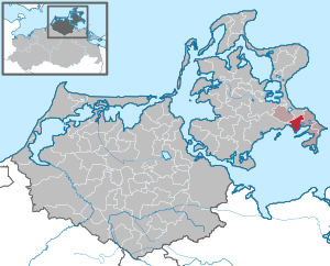
| Location of the community Lancken-Granitz in the district of Vorpommern-Rügen | ||
Lancken-Granitz is a municipality in the district of Vorpommern-Rügen on the island of Rügen in Mecklenburg-Western Pomerania. The municipality is administered by the Mönchgut-Granitz office with its seat in the municipality of Baabe .
geography
Lancken-Granitz is located about 15 kilometers east of Bergen on Rügen and four kilometers west of Sellin , south of the Granitz , on whose highest elevation the Granitz hunting lodge stands. The federal highway 196 runs through the municipality. In the south, Lancken-Granitz borders the Rügischen Bodden with the bay Having and the Neuensiener See . The municipality is partly located in the Southeast Rügen Biosphere Reserve .
Districts
The municipality has the following districts:
- Blieschow
- Burtevitz
- Dummertevitz
- Garftitz
- Gobbin
- Lancken-Granitz
- New Reddevitz
- Preetz
history
Lancken-Granitz was first mentioned in a document around 1250. The church was built in the 15th century.
The fact that the area around Lancken-Granitz was already settled in the Neolithic is proven by the four remaining large stone graves near Lancken-Granitz , which are just under a kilometer southwest of the village.
The place was part of the Principality of Rügen until 1326 and then the Duchy of Pomerania . With the Peace of Westphalia of 1648, Rügen and thus also the area of Lancken-Granitz became part of Swedish Pomerania . In 1815 Lancken-Granitz came to the Prussian province of Pomerania as part of New Western Pomerania .
Since 1818 Lancken-Granitz (until July 11, 1950 only referred to as Lancken ) belonged to the district of Rügen . It was only part of the Putbus district from 1952 to 1955 . The community then belonged to the Rügen district in the Rostock district until 1990 and became part of the state of Mecklenburg-Western Pomerania in the same year. The district of Rügen, which has been called this again since 1990, was merged in 2011 in the district of Vorpommern-Rügen.
On July 1, 1950, the previously independent community of Groß Stresow was incorporated.
politics
In the local elections in June 2009, Henny Hoffmann (independent) was elected mayor and was confirmed in office in 2014.
Coat of arms, flag, official seal
The municipality has no officially approved national emblem, neither a coat of arms nor a flag . The official seal is the small state seal with the coat of arms of the region of Western Pomerania . It shows an upright griffin with a raised tail and the inscription "GEMEINDE LANCKEN-GRANITZ * LANDKREIS VORPOMMERN-RÜGEN".
Attractions
- Saint Andrew's Church
- Large stone graves near Lancken-Granitz
- Great stone graves near Burtevitz
- Great stone grave Dummertevitz ("goat stones")
- Half-timbered rectory from the second half of the 18th century. The original interior room layout of the seven-axis building with a half-hip roof has been preserved.
Web links
Individual evidence
- ↑ Statistisches Amt MV - population status of the districts, offices and municipalities 2019 (XLS file) (official population figures in the update of the 2011 census) ( help ).
- ↑ Main Statute, Section 1, Paragraph 1 (PDF).
- ^ Lancken-Granitz in the Genealogical Place Directory
- ↑ Main Statute, Section 1, Paragraph 3 (PDF).


